

Where is the boundary of the Iberian Peninsula?
Historically and culturally, the Iberian Peninsula comprises Portugal and Spain and is bounded by the Pyrenees. But is this the most accurate way to define it?

A few months ago, I came across a screenshot of Google Maps on TikTok1, which I want to use to begin the story I’m telling you today.
.")
What do you think? Well, yes, on Google Maps, the Iberian Peninsula only has a 4.5 when it really deserves much more. And well, there’s also the curious fact that Google Maps has decided to include much of southern France as part of the Iberian Peninsula, you can check it out for yourselves2.
After that, I discussed the issue with quite a few people, but it became clear to me that there is no clear consensus. So I will dedicate today’s article to this topic, to continue the debate.
What is a peninsula?
If we want to determine the size of the Iberian Peninsula, the first thing we need to clarify is the definition of a peninsula. Let’s start with the definition from National Geographic:
A peninsula is a piece of land that is almost entirely surrounded by water but is connected to the mainland on one side.
Okay, more or less what everyone has in mind when they discuss peninsulas3: pieces of land surrounded by water that, unlike islands, are connected to another larger piece of land.
The definition in the Encyclopaedia Britannica is somewhat more detailed:
Peninsula, in physical geography, a piece of land that is nearly surrounded by water. The word is derived from the Latin paene (‘almost’) and insula (‘island’). In its original sense, it connotes attachment to a larger landmass by a neck of land (isthmus) narrower than the peninsula itself, but it is often extended to apply to any long promontory, the coastline of which is markedly longer than the landward boundary.
This definition is much more comprehensive than the previous one. It refers to the original meaning of the word, but also recognises that its use is widespread and accepted to refer to any promontory on the coast.
What matters most to me is that these definitions are consistent in focusing exclusively on the coastline. It is irrelevant whether there is another physical separation (such as the Pyrenees), whether there is a political separation (such as the border between France and Spain), or whether there is an underlying division of tectonic plates (such as the Iberian subplate from the rest of the Eurasian plate). If you look closely, three of the four reasons usually given for establishing the dividing line of the Iberian Peninsula in the Pyrenees do not apply. The fourth would be that it is the narrowest part of the isthmus.
But is this true? Here is an image with four possible lines that trace the narrowest point of the isthmus.
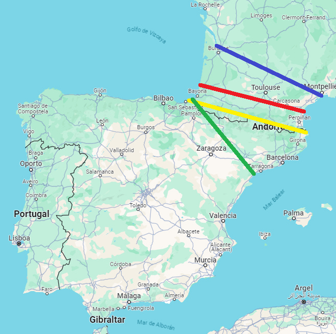
Without looking at Google Maps or doing any other research, which do you think is the shortest line? With the lines drawn, you probably already suspect that the answer is not the Pyrenees, but it is also not what I initially thought when I first explored the problem. Here is the length of each of these lines:
Blue (Montpellier - Bordeaux): 423 kilometres.
Red (Les Landes - Narbonne): 371 kilometres.
Yellow (The Pyrenees): 417 kilometres.
Green (Biarritz - Cambrils): 340 kilometres.
Knowing this, where would you prefer to draw the dividing line on the Iberian Peninsula?
On a historical-comic note, the Visigothic kingdom of Toulouse and Theodoric I would surely have voted for blue.
A cultural matter
Beyond the abstract game of finding the minimum width of the isthmus, the reality is that the result is irrelevant.
The definition of a peninsula is vague enough to allow us to establish the boundaries that suit us best. The cultural weight is undeniable, and it makes perfect sense that historically we have chosen to associate the idea of the Iberian Peninsula with a border that has remained almost intact for more than five centuries. A border that also has one of the most important mountain ranges in Europe and, if we want to be pedantic, also has a division below the Earth’s crust in the form of the Iberian subplate. As I said at the beginning, none of these ideas defines the idea of a peninsula as such, but they certainly simplify the concept considerably.
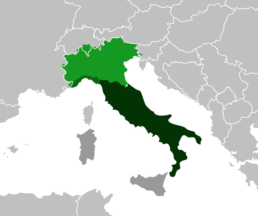
The case of the Iberian Peninsula is not unique. There are many examples within Europe, such as the Italian Peninsula. It is generally accepted that the Italian Peninsula is composed of the entire continental territory of Italy, excluding Sardinia, Sicily and the other islands. This is not governed by the minimum size isthmus we have been looking for, but as in the case of the Iberian Peninsula, it coincides with a mountain range (the Alps) and a political border (that of Italy after the Second World War).
It is much more complicated to explain why we commonly refer to the Balkans as the Balkan Peninsula. We can say that there is indeed a protrusion and that, in a way, it is mainly surrounded by water: the Adriatic, Mediterranean, Aegean, and Black Seas4. In this case, unlike the Iberian Peninsula, there is no isthmus that is narrower, as the peninsula widens continuously as it approaches Central Europe. Perhaps this is why the Encyclopaedia Britannica clarifies that the definition of a peninsula has been relaxed to include any large promontory.

If we are being pedantic, this problem exists with many peninsulas in the world, possibly the majority. Does the Korean peninsula include the entire territory of the two Koreas? Where is the border of Indochina? Does the border of the Arabian Peninsula correspond to the border of Saudi Arabia? What percentage of the state of Florida is within the Florida peninsula? Well-defined peninsulas are in the minority, although they do exist. There are some that are well-defined, separated by isthmuses that are narrow and distinct enough that there is no room for doubt, although only three come to mind: Valdés Peninsula (in Argentina), Paraguaná Peninsula (in Venezuela), Peloponnese Peninsula (in Greece).
Also, a matter of perspective
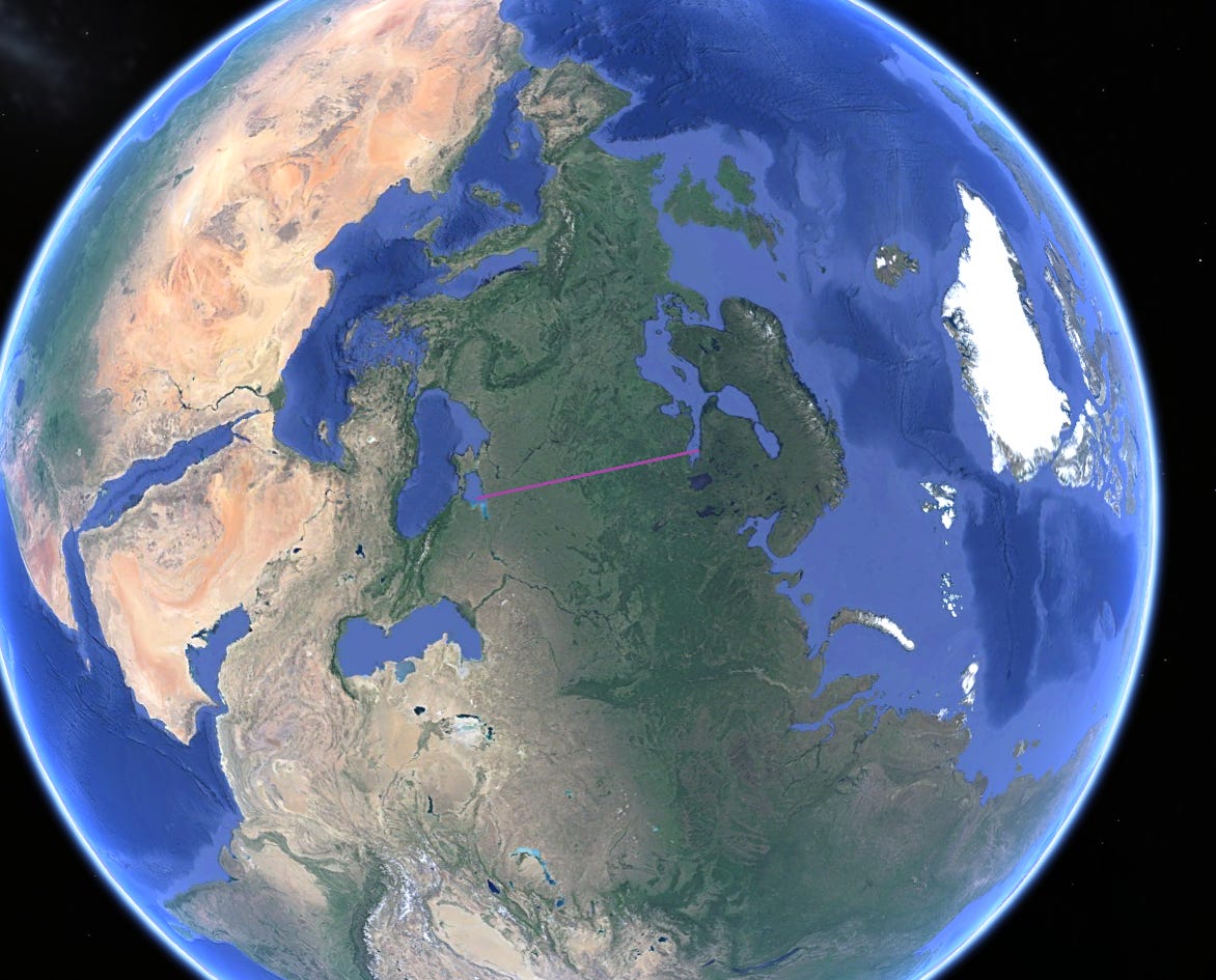
One of the most interesting comments I came across when I first discussed this topic was something as simple as changing the perspective of the map. This allows us to see the Iberian Peninsula in an unusual way, which makes it much easier to visualise the problem at hand. I took the idea and brought you a screenshot from Google Earth so that the borders don’t appear. Moreover, I drew a curious line that would define the Iberian Peninsula as a promontory of the line connecting the coast of Brittany with Marseille.
Perspective, together with cultural consensus, can end up being everything. The classic example is the definition of Europe as a continent. If we stick to the geographical definitions of peninsula and continent5, Europe would be nothing more than a peninsula in the western part of the great continent of Eurasia. Furthermore, that large peninsula would not include Scandinavia, which would be another peninsula of the great Eurasian continent.
This perspective, which seems far-fetched, was exploited during the Cold War by American propaganda to raise awareness in Europe of the Soviet threat. Robert M. Chapin published two maps in Time magazine in 1952 showing the Soviet Union’s advance in the world and how Europe and South Asia were being trapped by the communist giant. If this campaign had used the usual maps, the perspective would have prevented it from having the impact that it did with its two maps. In both maps, the Soviet Union is shown at the bottom, and all the ‘threatened’ territory at the top, as if it were cornered.
")
")
Beyond propaganda and questioning Europe’s status as a continent, this type of perspective can also serve to better understand the world we live in. The Soviet threat, as caricatured by Chapin, never materialised, but this same perspective made it easier to explain the great energy dependence that much of Europe had (and still has) on Russia. It was not a whim, but the reality that there was a vast territory, with vast resources, which has been providing energy for decades to a small Europe lacking in resources of its own.
By popular demand, here’s a button for procrastinating, in case you have plenty of things to do, but you don’t feel like. Each time you click on it, it will take you to a different map from the more than 1,200 in the catalogue.
If you like what you read, don’t hesitate to subscribe to receive an email with each new article that is published.
Yes, I spend more hours on TikTok than I would like, but at least I’ve managed to get the algorithm to serve me interesting content
Interestingly, it is the only peninsula in Europe that shows its outline if you search for it on Google Maps. This is not the case with the Italian peninsula, the Balkan peninsula or the Scandinavian peninsula.
Like if there would be people out there discussing peninsulas all day. But you get my point.
Another interesting issue is what we consider to be a sea and what we consider to be a gulf. This also has a lot of cultural significance. For example, in Spain we use the term Cantabrian Sea to refer to the sea off the north coast of the country, while the rest of the world refers to that body of water as the Bay of Biscay.
We also discussed the definition of continent in this other article.
Pretty curious, indeed. Mainly to me, that I've lived in a frontier town between France and Spain all my life. In our case, the natural frontier is Bidasoa river.
I voted for the blue line because I am anti-French and pro-Spanish