

Maps of the month: January 2026
The most interesting maps and articles I came across in January 2026.

This year, as a new feature in the newsletter, I have decided to include a monthly edition in which I will include the most interesting maps or articles I have come across during that month. I will also bring some maps and articles that I had in reserve and that may be relevant to that particular month.
Another important thing to mention1: a couple of days ago was my birthday. And this is just relevant to understand the last map of the list, a special gift from my little niece. Don’t miss it.
Without further ado, here is a list of what you will find in this edition:
The United States’ attack on Venezuela
The international response to the United States’ attack on Venezuela
The US threat to Greenland
The Danish response to the United States
Why is Greenland important?
New map of Antarctica under the ice
The Flood of Villa de Guadalupe (1819)
Piltover, the city of progress
The largest map in the world
The awakening of the Europeans
The mythological monsters of the United States
A very special birthday present
The US attack on Venezuela
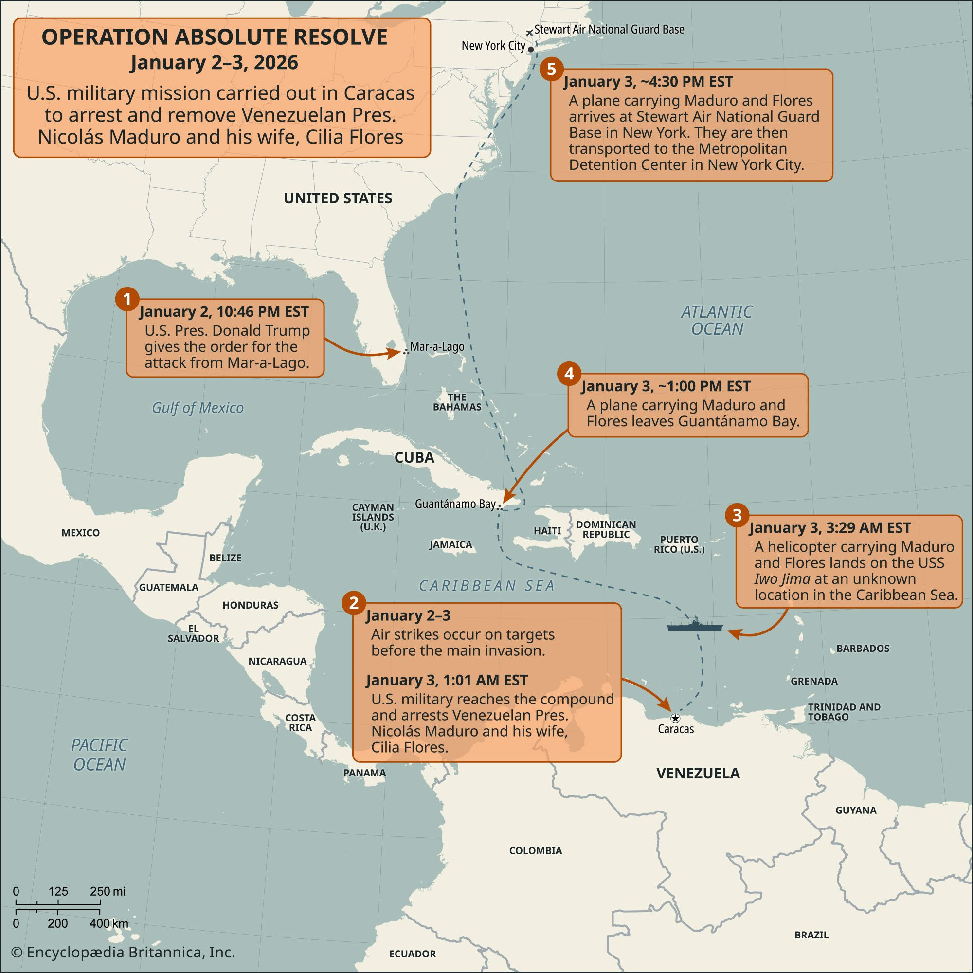
2026 has started with a bang. At the end of last year, the United States significantly increased its presence in the Caribbean, which was used to attack alleged drug traffickers’ boats. To be honest, I was convinced that this would remain a dubiously legitimate form of pressure from the United States to get Maduro’s government to change direction. But once again, I was wrong2.
The United States launched a surgical strike on Venezuela, as shown in the map above. On 2 January, at around 11 p.m., Trump approved the attack on Venezuela. In less than an hour, several locations in Venezuela, mainly related to the army, were bombed, and special forces managed to reach Nicolás Maduro’s residence and arrest him and his wife. This was just two hours and fifteen minutes after Trump approved the operation.
This, however you look at it, is a violation of international law. The only difference between this and the Russian invasion of Ukraine is that Putin was much more clumsy and did not achieve his objective in the first few days, as he had planned. Whether Maduro is a good or bad leader, a bad or terrible ruler, international law does not allow this type of interference. One does not justify the other.
The international response to the US attack on Venezuela
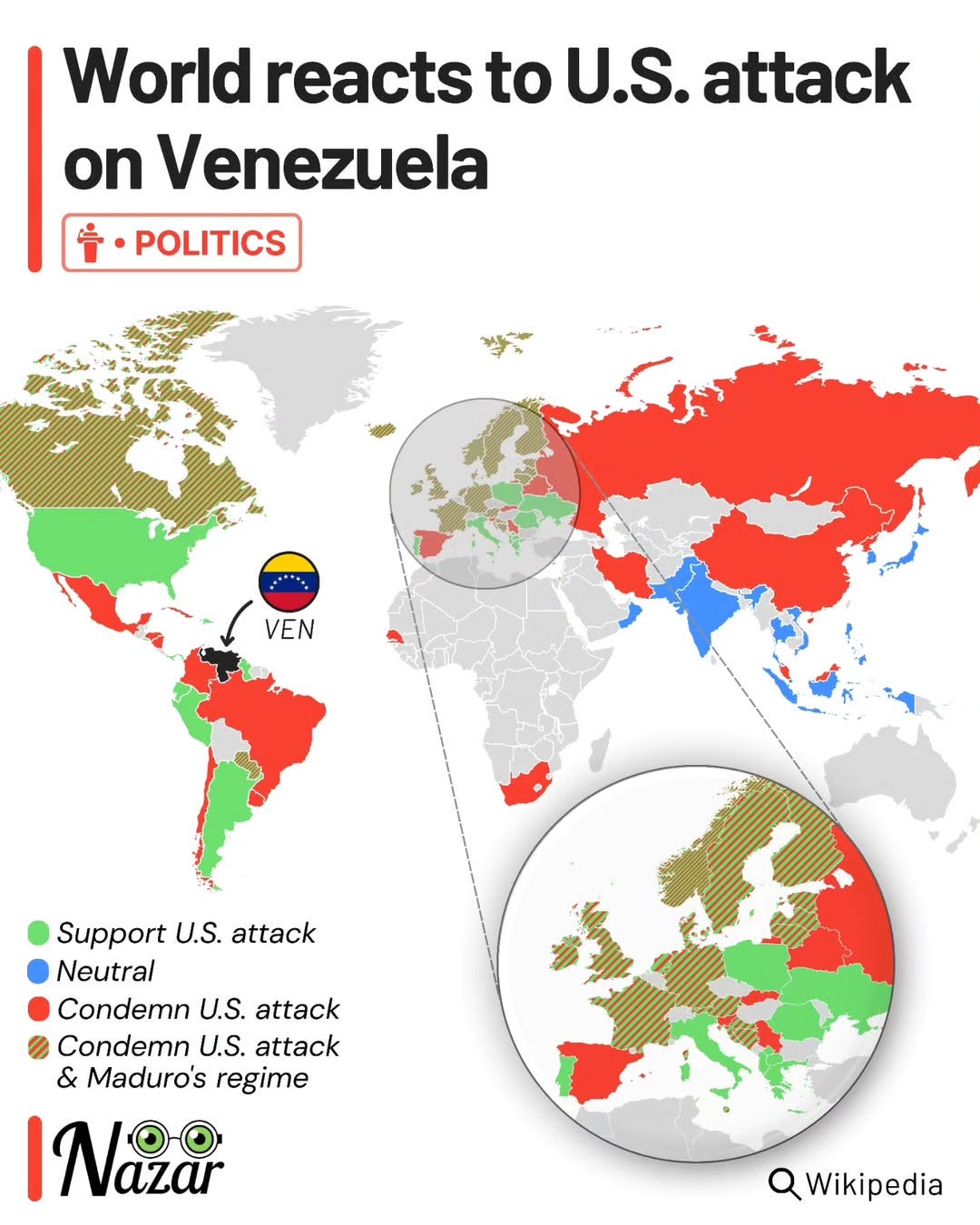
In the days following the attack, many countries publicly stated their views on Trump’s actions in Venezuela. This map clearly shows the division of opinion around the world. Some countries have openly applauded the US attack and the kidnapping of Nicolás Maduro. Others have condemned the US attack as a violation of international law, and others have done so while also condemning Maduro as a bad leader for Venezuela.
It is also easy to see at a glance that almost all the countries that have openly supported the US actions are countries governed by the right or the far right. In a way, these leaders have considered that the existence of a terrible left-wing3 ruler justifies this intervention. The same pattern can be observed in reverse, although much more moderately: criticism of the attack comes from left-wing governments, but also from centrist governments and even some right-wing governments.
Some interpret the responses of certain countries as the result of fear or an interest in aligning themselves with the United States and benefiting from possible future trade agreements. It is clear that we are living in fragile times, so it is important to choose our steps carefully.
The US threat to Greenland

We must not forget that we are in the age of social media and memes. Now anyone can go online and use AI to quickly generate a meme to express their position. And this image you see above is the work of Katie Miller, an American political advisor who was part of Trump’s first administration and was spokesperson for the Department of Government Efficiency (DOGE). Yes, the one led by Elon Musk.
The image speaks for itself. It does not seek an in-depth analysis, or even a far-fetched justification. It simply calls for controversy; it is pure propaganda that seeks to generate tension and, with luck, gain a handful of support in the face of the reaction against Americans that the image may generate.
All this would have come to nothing if it weren’t for Trump’s insistence that Greenland is a target for his administration and that he intends to gain control of it no matter what.
Here I need to leave you with a curious detail that has been bothering me for a few weeks: Trump is fascinated by maps. In other words, I share a hobby with Donald Trump, no less. And there is a possibility that Mercator is indirectly to blame for the whole mess with Greenland. You can read about it in this article by Susan B. Glasser in the New Yorker, but I will leave here THE quote that is giving me nightmares.
I said, ‘Why don’t we have that?’ You take a look at a map. So I’m in real estate. I look at a corner, I say, ‘I gotta get that store for the building that I’m building,’ et cetera. You know, it’s not that different. I love maps. And I always said, ‘Look at the size of this, it’s massive, and that should be part of the United States.’
— Donald Trump
Denmark’s response to the United States

It turns out that, as much as Trump and his supporters want to take control of Greenland, Greenland is part of the Kingdom of Denmark4. So, as expected, this has also caused great irritation in Denmark, but also in the rest of Europe and Canada. After his actions in Venezuela, Trump’s threats cannot be lightly ignored.
There have been responses that are equal to the circumstances, such as that of Mark Carney, Prime Minister of Canada, in Davos. But since I’ve shown you Katie Miller’s map, I feel compelled to share this wonderful response I found on TikTok, on Ronni Reitan‘s account.
It won’t solve the conflict or end up in the history books, but I have to admit that I found the map funny.
And I’m sure it will bring a smile to more than one of you as well.
Why is Greenland important?

Many of you may wonder why there is so much interest in Greenland, when it is just a large block of ice with barely 57,000 inhabitants. Trump’s narrative is that it is a strategic piece in defending the United States’ position against enemies such as Russia and China. This can be seen in part on this map, but the reality is much more complex.
Firstly, we cannot ignore the reality hidden beneath the ice of Greenland: vast reserves of critical minerals. These include zinc, nickel, copper, graphite and rare earths, but also significant reserves of uranium, oil, and gas. All of this lies beneath the ice and may not be exploitable for decades; however, there are those who believe that controlling these future reserves now is crucial.
The other reason is purely historical. The United States maintained a considerable military presence in Greenland after the end of the Second World War, at one point having up to 50 military bases. Since 2004, that presence has been limited to the Pituffik space base5 in northern Greenland. In addition, the Igaliku agreement, signed that same year, obliges the United States to negotiate any increase in its military presence beyond this base.
And perhaps negotiation is what Trump is trying to do. In his own way.
New map of Antarctica under the ice

Speaking of ice, let’s leave this single topic behind and move to the other side of the planet. This January, the most detailed map of the Antarctic landscape to date was published. And I’m not talking about the frozen surface, but what lies hidden beneath those kilometres of ice.
Thanks to high-resolution data obtained from satellites and precise analysis of ice movements, the authors of the study have produced a map that shows twice as many landforms as previously achieved, including completely unknown hills and valleys.
Knowing the bedrock hidden beneath the ice will provide a deeper understanding of how the ice will move in the future and how this may contribute to sea level rise, and at what rate. It will also aid detailed climate studies and the planning of future explorations of the frozen continent.
The Flooding of Villa de Guadalupe (1819)
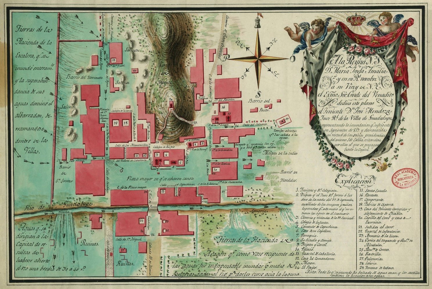
I found this map in Doug Greenfield’s newsletter, where he refers to this wonderful article by Pedro Zurita6.
In 1819, Villa de Guadalupe, which was still a separate municipality from Mexico City, suffered one of the many floods that had been common for centuries in the Valley of Mexico. The causes were a combination of extraordinary rainfall and several failures in the valley’s drainage system, which had been malfunctioning for over a century.
It was a disaster, but one among many that would have been nothing more than an episode in local history had it not been for this stunning map signed by Lieutenant José Mendoza. On it, the blue areas show the extent of the water in the town, as well as the areas that were entirely ruined after the flood. A terrible event, but a truly captivating map.
Piltover, the city of progress
This map is a gift for all lovers of League of Legends and the Arcane series. It is a map of Piltover, the city where the Arcane series is set, created by Cristina in her newsletter after interpreting the information available in the game and the television series.
It is based on a map that appears in Caitlyn Kiramman’s room in the series, from which Cristina interprets the possible location of iconic places in the series. Likewise, it is not a truth, but an interpretation that respects the urban logic and narrative of the game and the series. A real delight.
The largest map in the world

I had seen this map on other occasions, but I hadn’t come across it for some time, until a few days ago when I found it on Mappery. This map, as you can see, is officially the largest map in the world, as recognised by the Guinness Book of Records.
It is a work by Swiss artist Christoph Rihs, created on one of the cooling towers of a former natural gas power station near Meppen, Germany. The tower is 131 metres high, and the map covers some 26,000 square metres.
Today, it can still be visited as part of the Circuit Meppen facilities, which occupy the site of the former power station. Here you can check it on Google Maps, so you can see it with your own eyes.
The awakening of Europeans

This map elegantly shows the time at which the inhabitants of each European country tend to wake up, revealing significant differences between countries. However, these differences are much smaller than stereotypes would suggest. After all, there is only a 72-minute difference between the Swiss, who wake up at 7:13, and the Greeks, who wake up at 8:25.
What is inevitable is to observe the patterns. The south consistently wakes up later than the north, although I admit I was surprised to see that Central Europe wakes up earlier than countries such as Finland, Norway, or Ireland. However, what the map does not show is the time at which each European country usually goes to bed, which also varies.
In fact, to clarify that people in the south do not sleep more, I will also leave you with this map detailing the average hours of sleep in Europe.
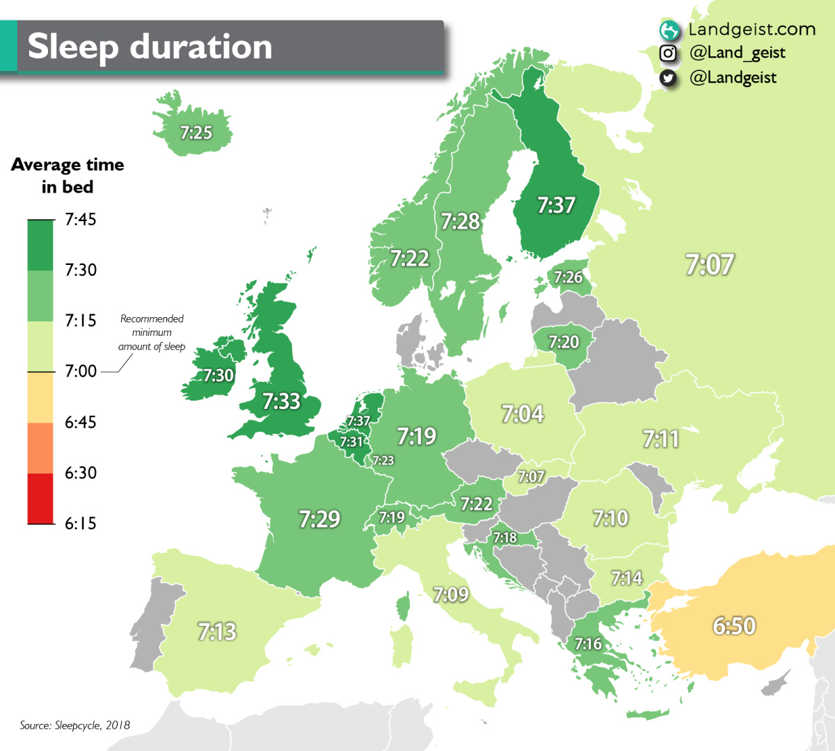
That’s right: people in Southern Europe sleep less than those in the north. Surprised?
The mythological monsters of the United States
")
This map of the United States created by Neil Parkinson is truly wonderful. It brings together all the folklore and mythology of the country and shows it through illustrations of some of the most iconic creatures in American geography.
It includes more than 30, some of which I was familiar with, such as Bigfoot (in California), Mothman (in West Virginia), La Llorona (in New Mexico and Texas) and the Jersey Devil (yes, from New Jersey). Of course, although the monsters appear at specific points on the map, often the myth extends over a much larger region.
A very special birthday present
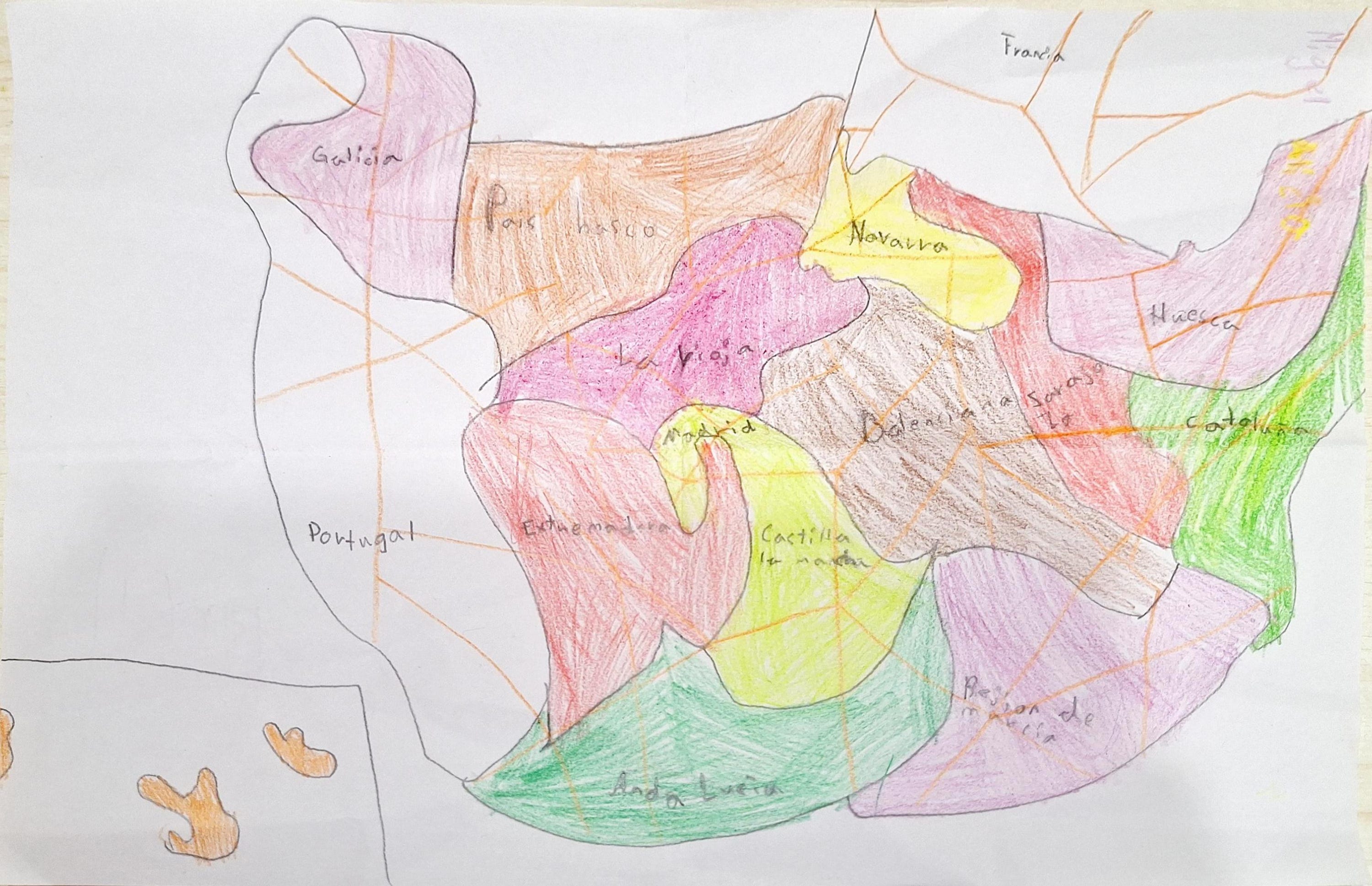
As I said at the beginning, last Friday was my birthday. Those who know me know that I am a terrible person at giving gifts. I have no particular appreciation for material things and, in general, on the rare occasions when I want something, I buy it before sharing that interest with anyone. You could say that I am one of those old-fashioned people who does not value the gift for the gift’s sake.
But of course, there is always a gift that makes a difference. And that gift is this map you see above, one of the best I have ever received. My little niece likes to draw, so before I celebrated my birthday last weekend with the family, she asked her mother what she could draw for me. My sister told her that I like maps, so she took a map of Spain she found lying around and tried to draw it.
She is seven years old and, as with all my nieces and nephews, I adore her deeply. The love and intention behind this drawing far outweigh all its oddities. That said, please let’s admire together the oddities of the map. I love the size of the Basque Country, the unexpected new status of Huesca7, and the fact that Valencia is in the centre of Spain, instead of by the Mediterranean. The only thing that hurts a little is that there is no reference to Segovia in the map. In fact, neither has Castile and León, despite being the largest region in Spain8.
How would anyone not love this map? ❤️.
By popular demand, here’s a button for procrastinating, in case you have plenty of things to do, but you don’t feel like. Each time you click on it, it will take you to a different map from the more than 1,100 in the catalogue.
If you like what you read, don’t hesitate to subscribe to receive an email with each new article that is published.
I know, not THAT important. But well.
Yes, I was also one of those who, in February 2022, believed it was impossible that Russia would dare to invade Ukraine, despite reports of a growing military presence on the border.
I’ll leave “left” in italics because this is also a topic that could be discussed at length.
The Kingdom of Denmark consists of three nations: Denmark, the Faroe Islands and Greenland. But Greenland is not part of Denmark.
Also known as Thule.
In Spanish, but really worthy.
Huesca is just one of the 52 provinces of Spain, but in this map it has the status of Comunidad Autónoma, of which we have 17 in Spain.
I do live in Segovia, which is part of Castile and León. My niece lives in Madrid, which does show up in the map.
I wonder how much the average waking time depends on the timezone. Spain is very west for its timezone, France is one hour ahead of England, despite being similar in longitude, and Germany is towards the east of its zone. Perhaps Italy and Portugal are the true outliers!
Happy Birthday! A lovely present! Lucky man. 😃