

Tourist maps of Spain, by Jacques Liozu (1953)
A collection of tourist maps of Spain from the mid-20th century, decades before the tourism boom.

Tourism is a fairly modern phenomenon, at least as we understand it today. It is true that in Ancient Greece and Rome there was a fascination with some of humanity's great constructions, but although they aroused the interest of many thinkers, travelling to visit those monuments was within the reach of very few. During the Modern Age, tourism gradually began to take hold in Western societies and, after the Second World War, much of the world understood the value of cultural exchange that travel brings. In addition to being an excellent diplomatic tool for smoothing over differences and building a more peaceful world.
In this context, a collection of books dedicated to different countries and regions of the world was published in France: The World in Colour1. This collection was edited by Doré Ogrizek, and the seventh volume was dedicated to Spain. The original French version was published in 1951, but it was soon translated into Spanish, with the Spanish version seeing the light of day in 1953. It is not a tourist guide like the ones we have today, but rather delves much deeper into the culture and history of the country it proposes to visit. It explores Spanish art in depth, from Altamira to Goya, discusses its most memorable literary milestones and, unsurprisingly, also devotes quite a few pages to cultural peculiarities such as bullfighting and Holy Week.
One of the great things about Ogrizek's work is the many illustrations that accompany the texts. Among all those pages, as one would expect, there were also maps, fantastic tourist maps illustrated by Jacques Liozu2. These maps are used in the history sections that the author devotes to each of the regions of Spain. And I am going to devote today's newsletter to them.
The Heart of Spain
The first of the maps is dedicated to the whole of Central Spain, covering much of Old Castile and all of New Castile3.
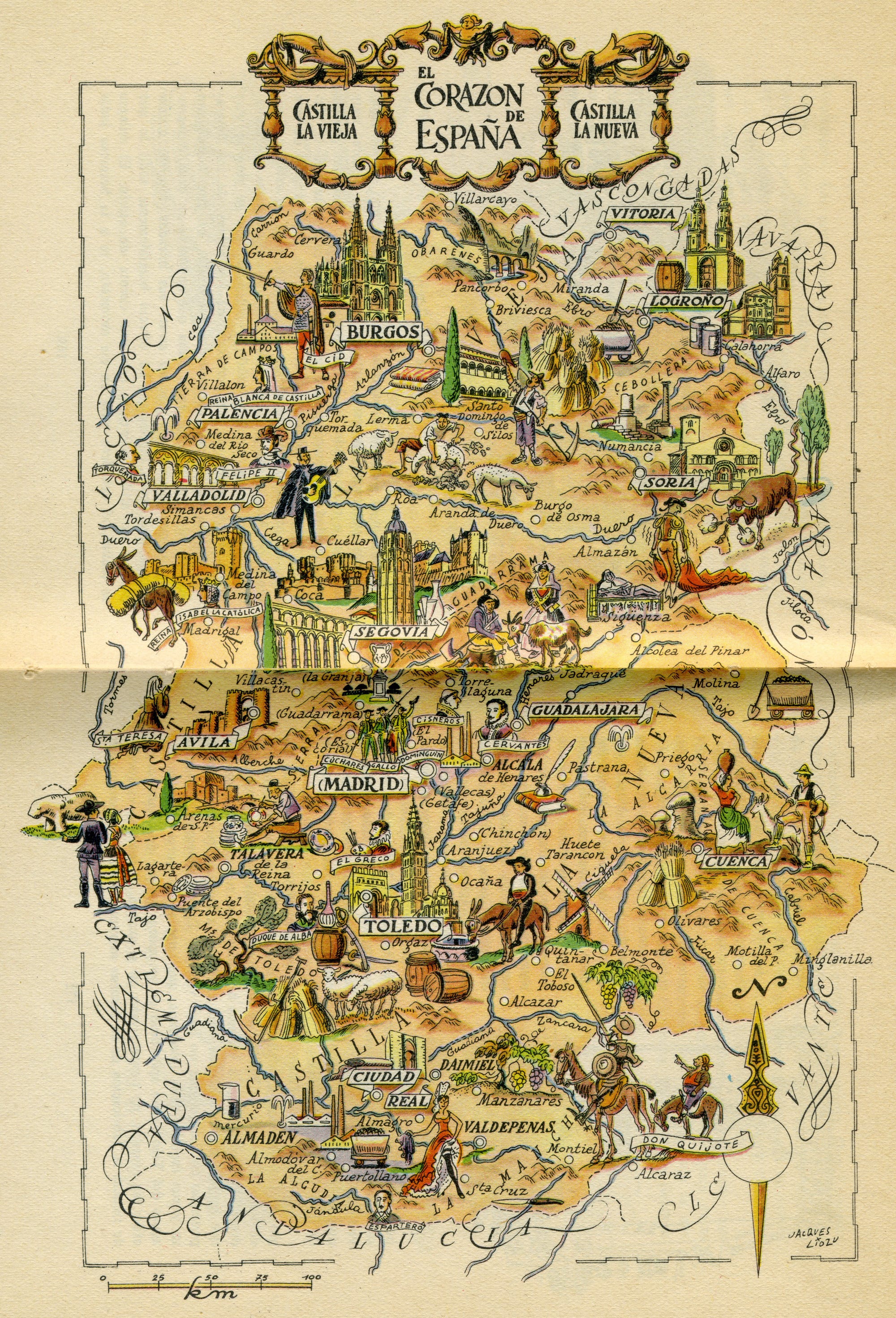
It is curious to note the choice of monuments and natural environments that were highlighted by Jacques Liozu when creating this map. Almost all the cities that are currently UNESCO World Heritage Sites are prominently featured on this map. This is the case of Segovia, which plays a special role, as its three main monuments are represented4. The case of Cuenca is surprising, as it is marked as a relevant city, but none of its most representative landmarks are shown.
Beyond the provincial capitals, the map also takes the opportunity to show some of the most iconic places, such as the mills of Quintanar de la Orden, the Pancorbo gorge, Numantia and the important industry of Puertollano. The illustration also features notable cultural traditions, such as references to transhumance in the northern plateau, the verracos in the province of Ávila, and Don Quixote.
Western Spain
This map groups together the entire non-coastal region that borders Portugal. At the time, it grouped together the autonomous communities of León and Extremadura.
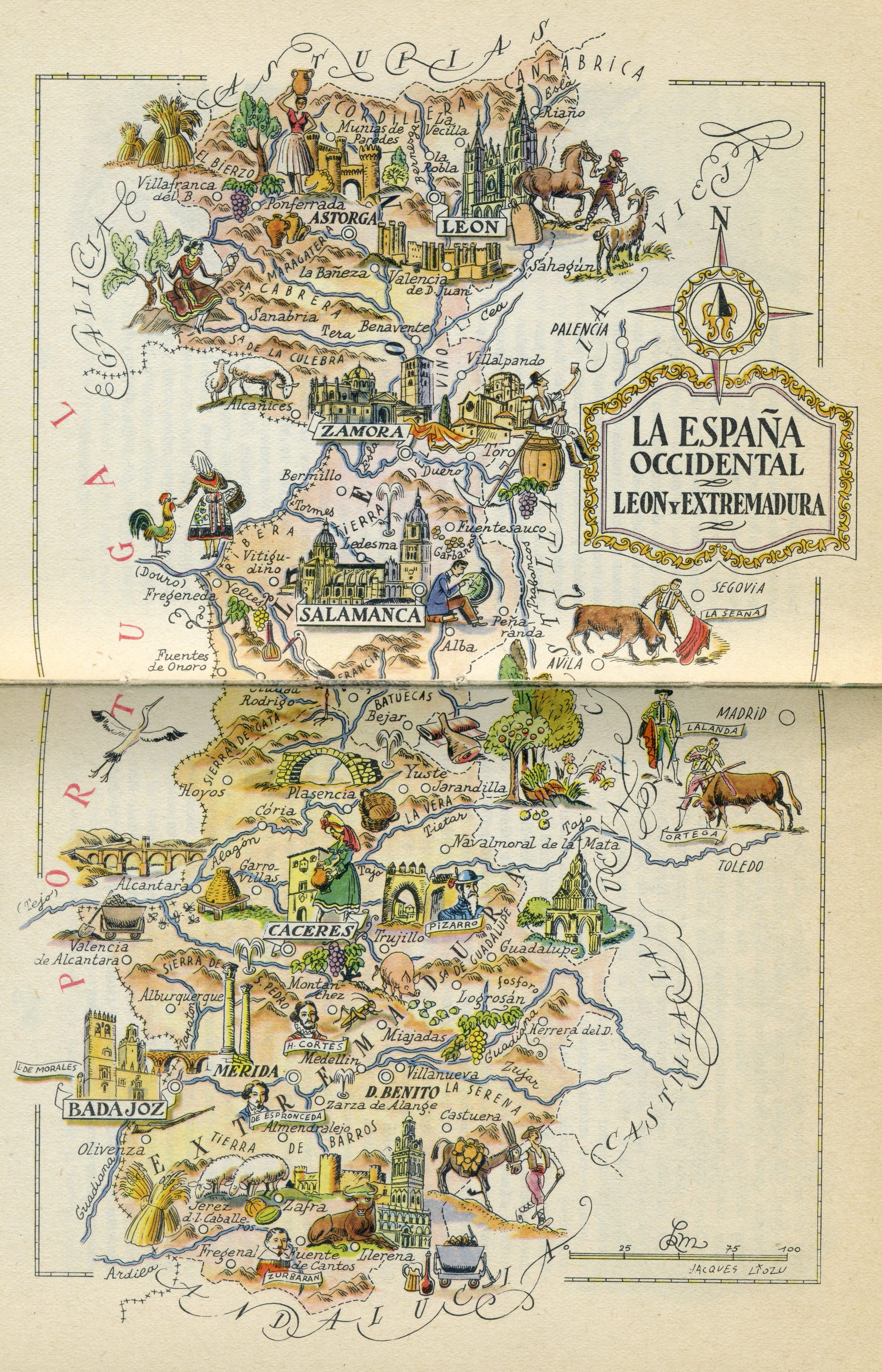
All the provincial capitals appear as significant cities, with special emphasis on the cathedrals of Salamanca, Zamora, and León. Some towns, such as Astorga, Don Benito and Mérida, enjoy special prominence, as they are population centres with a weight very similar to that of the other provincial capitals.
In Extremadura, a land of conquerors, both Pizarro and Hernán Cortés appear. The importance of bullfighting is also evident on this map, which features three iconic bullfighters of the time: De la Serna, Lalanda and Ortega. Livestock and crops appear throughout the region, as well as a large ham next to Béjar.
The Cantabrian North
Here we find the entire Cantabrian coast, which includes Galicia, Asturias, the Basque Country and Cantabria, which at that time was still part of Old Castile.
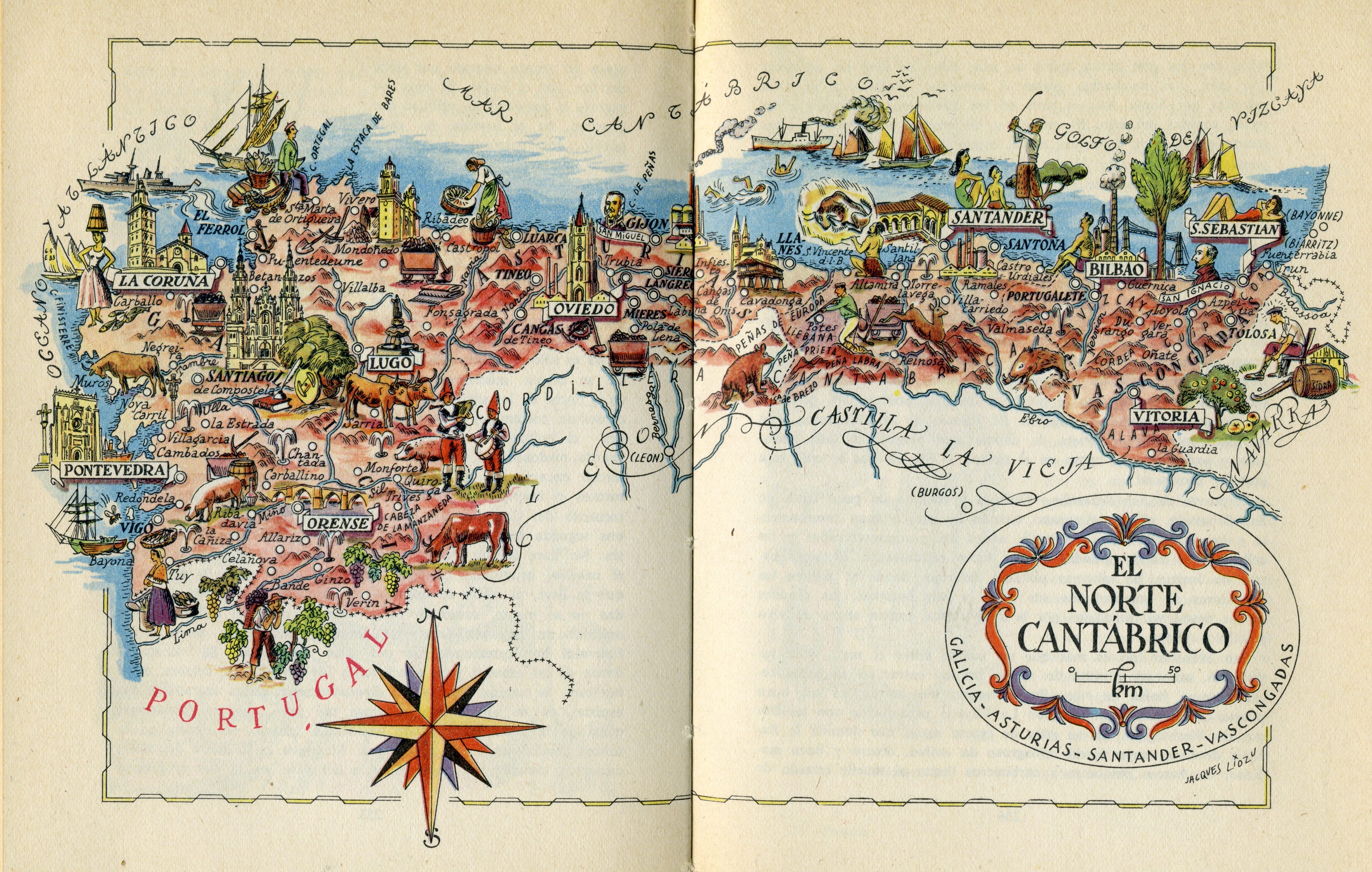
This is the first map in which the sea plays a leading role, and this is reflected in the multitude of ships characteristic of each region that can be seen on it. The beaches also play an indirect role, as shown by the images chosen to represent Santander and San Sebastián, possibly the two most popular beach destinations in Spain in the first half of the 20th century. Other provincial capitals are represented by their cathedrals, and the case of Lugo is surprising, as there is no trace of its iconic Roman wall.
Cattle and pigs are the protagonists of the rural areas of Galicia. In the mountainous areas of the rest of the Cantabrian coast, some of the most recognisable wild animal species of the peninsula appear, such as bears, wild boars, and roe deer. The great fish and seafood culture also features in some images, as is the case in Ribadeo.
The Northern Pyrenees
Navarre, Aragon, and Catalonia cover the northern Pyrenees of the Iberian Peninsula.
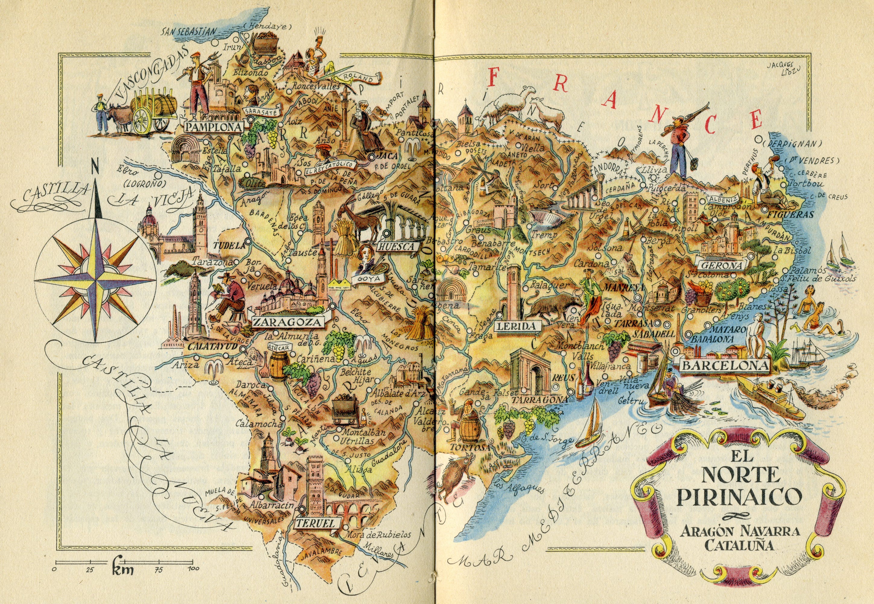
Clearly, Barcelona was not yet the Barcelona we know today.
The author entirely ignores Gaudí, whose work had not yet achieved the worldwide fame it enjoys today. The opposite case can be seen in Teruel and Albarracín, which appear in a significant size and with several of their most iconic monuments. Goya is correctly located in Aragon, but incorrectly south of Zaragoza, instead of in Fuendetodos, the town where he was born.
The Costa Brava already had people swimming and many sailing boats ploughing the Mediterranean Sea. In the rural inland areas, vegetables and fruit abound, which are not so common in other regions.
The Spanish Levante
The Spanish Levante covers the Valencian Community and Murcia, which before the territorial reform of democracy still consisted of the provinces of Albacete and Murcia.
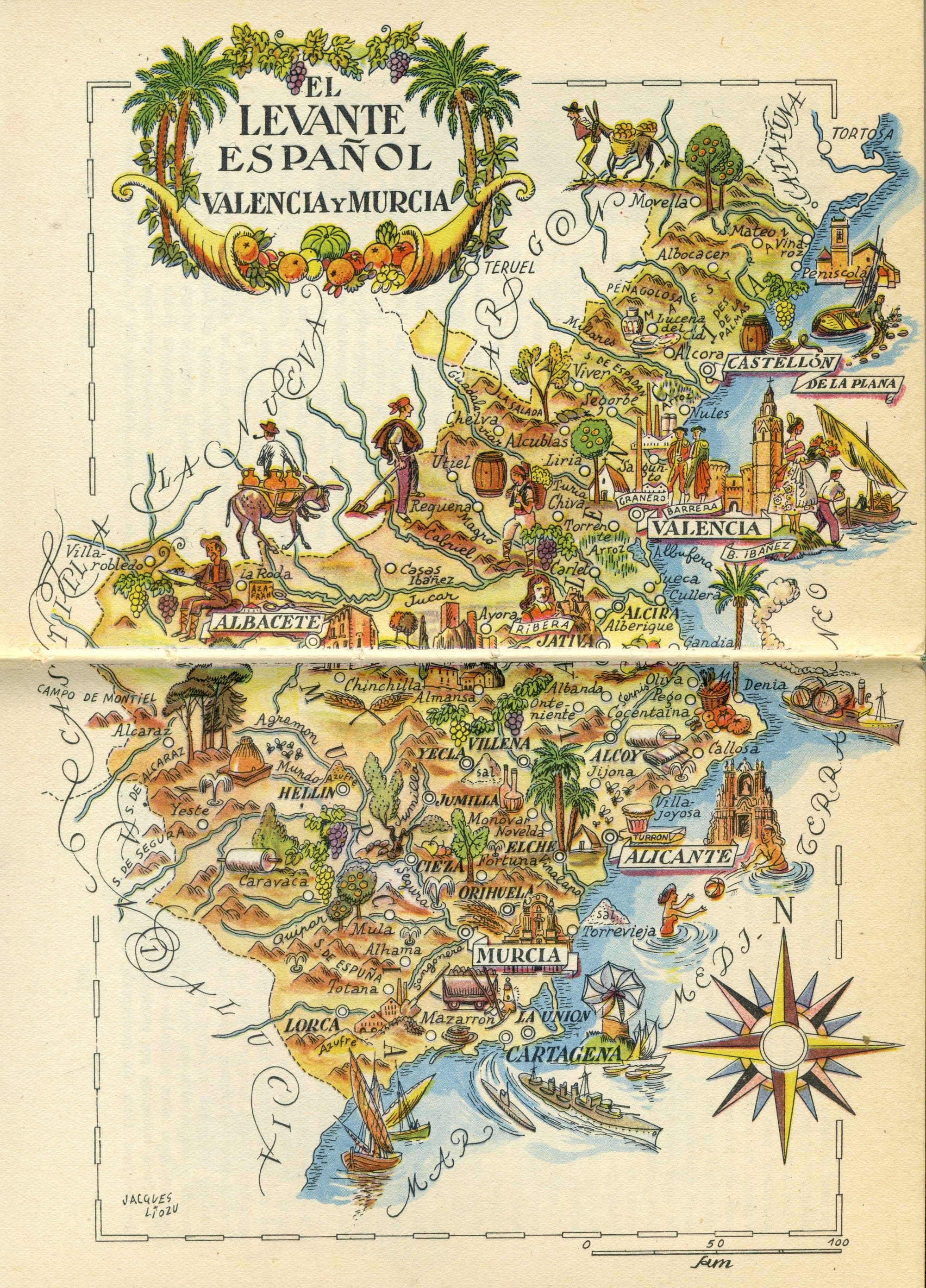
Valencia, in addition to its cathedral, also has a fallera5 making the offering of flowers. Despite not being the most wine-producing region today, on this tourist map the Levante stands out as the territory with the most references to vine cultivation, harvesting, and transport.
Unlike other previous maps, this one has virtually no monuments beyond the provincial capitals, except for Peñíscola and Almansa. Even so, there is no shortage of beach goers or the characteristic turrón of Alicante.
Southern Spain
This region corresponds exactly to the autonomous community of Andalusia.
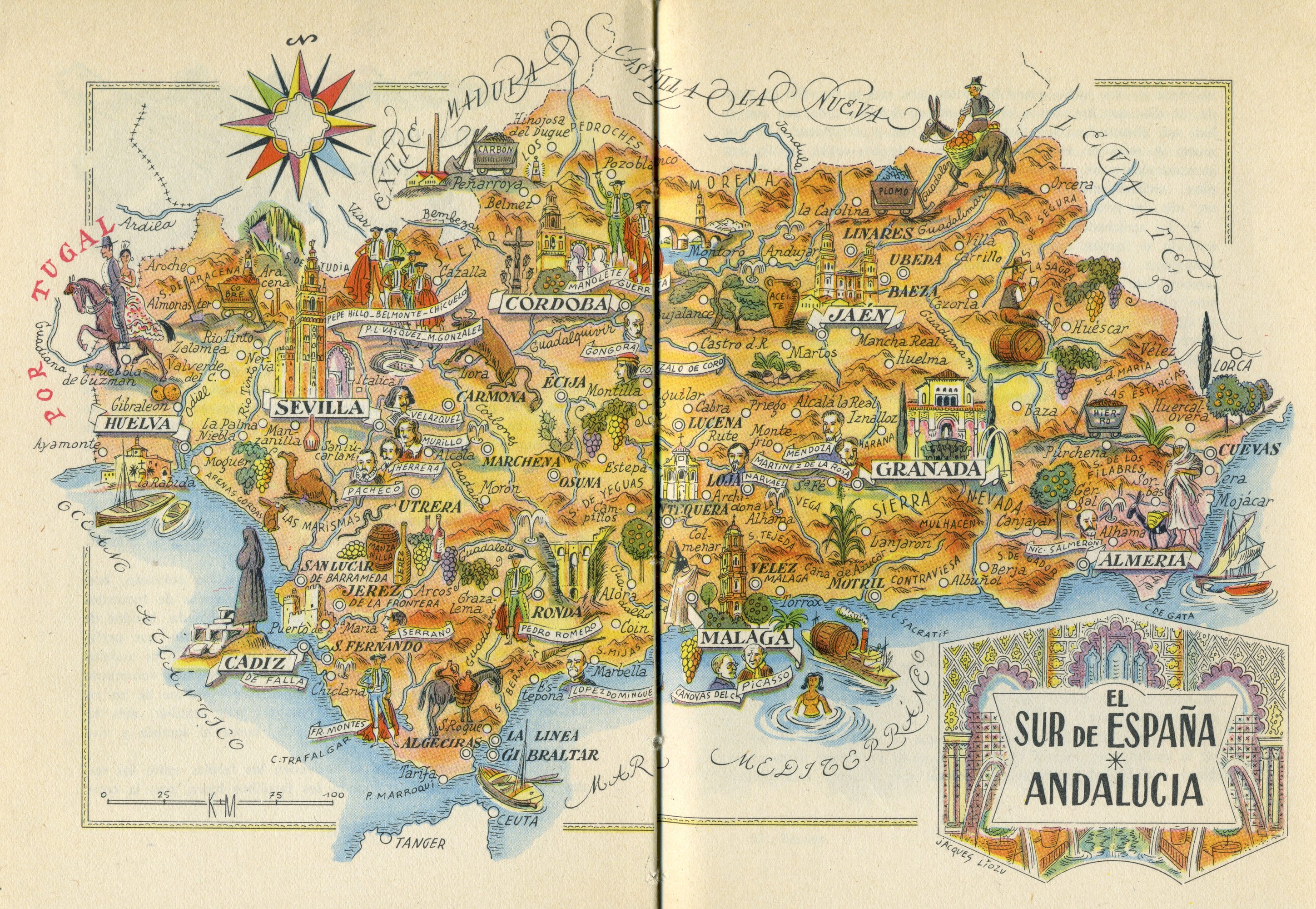
Of all Jacques Liozu's maps, this is undoubtedly the one with the most representations of famous people. What's more, it has all kinds: painters (Velázquez, Murillo, Picasso), writers (Góngora, Herrera, Martínez de la Rosa), bullfighters (Manolete, Pedro Romero, Francisco Montes), politicians (Cánovas del Castillo, Narváez, Nicolás Salmerón), and military figures (Gonzalo de Córdoba). Both the Alhambra in Granada and the Giralda in Seville appear larger than the other monuments, highlighting their importance at that time.
The map of Andalusia is also the one in which mining plays the most prominent role, as the mountains surrounding the region are marked with deposits of copper, iron, coal and lead. Unsurprisingly, olive oil is the main feature in Jaén and wine in Jerez de la Frontera. And well, what is possibly the strangest detail is also found on this map: a dromedary on the Seville coast6.
The Spanish Islands
The last region covers the islands of Spain and is illustrated with two maps, one for the Balearic Islands and another for the Canary Islands.
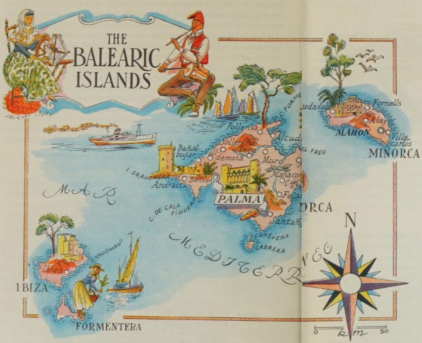
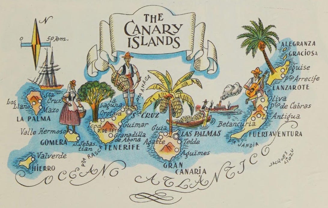
Perhaps the most striking feature, although not necessarily surprising, is the absence of any reference to beaches and bathers in either archipelago. Mass tourism did not begin to be systematically promoted until the 1960s7, so these maps cannot yet reflect that reality. What we are left with is a very intriguing representation of what was characteristic of both archipelagos before tourism changed them forever.
The talayots occupy a privileged place on the island of Menorca, with no representative monument from Ciutadella appearing. In Majorca, the limelight is shared between Palma, the capital, and Bellver Castle. In Ibiza, the historic centre of the capital, Dalt Vila, is highlighted above the rest.
In the case of the Canary Islands, almost all the limelight goes to its agriculture and customs. Bananas occupy the central part, with the banana tree of Gran Canaria, but also with the boat that transports bananas. Volcanoes appear as mountains, without giving them that important feature of the nature of the Canary Islands.
By popular demand, here’s a button for procrastinating, in case you have plenty of things to do, but you don’t feel like. Each time you click on it, it will take you to a different map from the more than 1,100 in the catalogue.
If you like what you read, don’t hesitate to subscribe to receive an email with each new article that is published.
You can consult a copy of this book for free on the Internet Archive: Spain and Portugal.
This is not the first time Liozu has been around here, he was also the author of a wonderful collection of maps for Pan Am in-flight menus.
All the regions used in the maps are former regions. Political divisions of Spain changed in 1978 to the current ones.
Out of curiosity, I looked into it and found that in the 20th century there were no dromedaries or camels. But, to my surprise, it appears that there are archaeological remains that show the use of camels and dromedaries in much of Europe during the Roman Empire. More information here.
Spain beaches were not popular outside Spain around 1950. For reference, in 2024 Spain received 93 million international visitors. In 1950, it was only half a million.
Nice find!
These are wonderful maps. And... I think Segovia is lovely (nicer than Toledo!), though the Alcazar is a little kitsch. Interesting also that San Lorenzo de El Escorial doesn't feature. I suppose it wasn't intended to be a tourist place then, whereas now it features as a day out from Madrid.