

The Atlas for a Nuclear War
A detailed propaganda atlas published in 1982 against the proliferation of nuclear weapons, dealing with their past, present and possible futures.

World War II ended in brutal fashion. In just three days, two nuclear bombs were dropped on Hiroshima and Nagasaki, precipitating Japan's surrender just six days later, on 15 August 1945. I will not dwell on the appropriateness of the action that was taken. Much has already been written about it, and I have no new insights to offer1. Yes, the two bombs prevented a land invasion by the United States and possibly also by the Soviet Union from the north. On the other hand, those two bombs were not harmless. They killed more than 200,000 people, the vast majority of them civilians2.
But the consequences went far beyond all those people who were unable to continue their lives. Four years later, the Soviet Union carried out its first nuclear test and, with it, the world discovered a new, hitherto unknown fear: nuclear war.

There are more than 20 known cases in which the world came close to nuclear conflict3. Fortunately, none of them materialised, but they did have a profound impact on society.
Today, I’m bringing to you one of the best examples I know of this latent fear and the anti-nuclear movements that proliferated during the second half of the 20th century: The Nuclear War Atlas4.
This is a magnificent work by the American geographer and activist William Bunge. In a single page, published in 1982, the author presents 28 maps and with them digs into four ideas that are key to understanding the fears and the reason for the struggle of many: blast, radiation, star wars and the future.
Blast
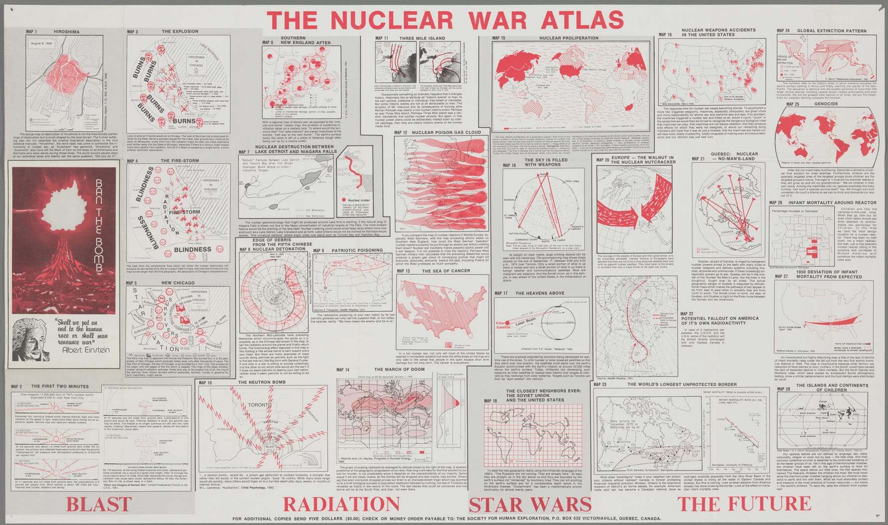
It all starts with the first bomb, or at least the first one that was actually used for war purposes. On 6 August 1945, the Enola Gay bomber flew over the city of Hiroshima and dropped a bomb that swept away much of the city. William Bunge uses this fact in his first map and, without hesitation, makes his propagandistic intent clear in the accompanying text. He states that, just as ‘Auschwitz’ became a symbol of genocide, ‘Hiroshima’ became a symbol of nuclear war. He then categorically equates the actions of Germany and the United States for their brutality.
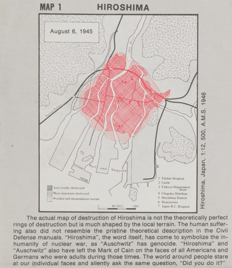
To better connect with the Americans, Bunge presents another map showing what the effects of the H-bomb would be if it were dropped on the city of Chicago. The H-bomb was one of the most destructive bombs designed as part of the nuclear race, with 1000 times the power of the one dropped on Hiroshima. The author goes into great detail about the consequences of that bomb, representing several concentric circles around Chicago:
The bomb crater would have a radius of 4 kilometres (2.5 miles), which would be flooded by water from Lake Michigan.
At 6 kilometres (3.8 miles), all people would be vaporised.
At 11 kilometres (7 miles), every individual would be burned and steel would melt.
At 17 kilometres (10.7 miles), only those in a deep shelter would survive.
At 23 kilometres (14.2 miles), all buildings would collapse.
At 37.5 kilometres (23.3 miles), third-degree burns would be guaranteed.
At 56 kilometres (35 miles), second-degree burns would be guaranteed.

This map is complemented by another map showing the effects that would follow immediately after the blast, such as a firestorm that would ensure that any survivors within a 35-mile radius would be permanently blinded. The fifth map focuses on the direct social consequences of such a disaster: it shows how all the injured would have no way of subsisting in that territory and would be forced to migrate in all directions. To reinforce the propagandistic narrative, Bunge refers to these routes as “invading survivors”, illustrating the potential disruption that the sick, insane, dying, or blind would cause in the surrounding regions.
Radiation
After the immediate consequences, it is time to worry about radiation. Unlike direct damage, radiation can have much longer-term consequences and reach far greater distances than we might intuitively expect. To make this point, Bunge considers the consequences of the nuclear tests that have been carried out around the world may have been, far beyond the site of the blast. The example he takes is the fifth Chinese test, launched on 9 May 1966, and indicates how the debris from that explosion moved around the world over the next eight days with the help of westerly winds.

Following the path of fear, the author turns to the Three Mile Island incident of 1979. On 28 March of that year, a reactor suffered a partial core meltdown that resulted in a release of radioactive gases into the atmosphere of between 2.5 and 15 million curies5. The map used by Bunge shows how the radiation was distributed over the following days, initially northwards, but then much more erratically in all directions. In addition, he also mentions that while the Three Mile Island accident may have been unavoidable, nuclear power plants can also become an easy target for any enemy to inflict great damage.

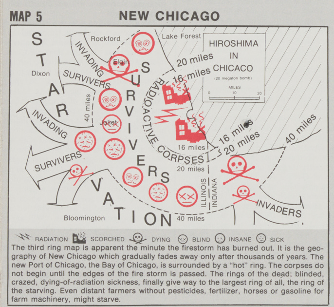
In 1982, while the consequences of radiation were known, the atlas needed a map that made it clear that there was no escape. If there was a nuclear war, a large part of the population would die from all the causes outlined above, but even those who survived would face a sea of cancer from the radiation.
Star Wars
Having explained all the dangers of dealing with nuclear materials, it is time to show the major problem facing the world as late as 1982. In 1949 only the Soviet Union and the United States had access to nuclear weapons, but 33 years later several countries already had nuclear weapons and many more could develop them in five years (gridded) or ten years (dotted).
On this map, Bunge doubled down. It is clearly a work of anti-nuclear propaganda, but he made a series of predictions with limited foundation. France, the UK, India, China, and South Africa6 had already joined the club, yet while many countries had their secret nuclear programmes, the vast majority lacked the funding to carry them out.

The next map goes much further and states that the sky was already full of weapons in 1982. The author claims that a tiny fraction of what populated the space were communications satellites, and that the Soviet Union was far ahead of the United States. In part, Bunge is cautious and does not say that there were nuclear weapons in space, which there were not. But there were no weapons of any kind in space either, although there were some satellites that had built-in defence systems7.

As a cherry on top of Bunge's particular vision of current affairs, it was necessary to iterate on the previous idea to strike fear into the enemy. It is not that the Soviet Union could attack the United States, it is that they were already there, flying over the American skies every day. On the map, the author draws a grid across the world map and, in the legend, makes it clear that the vertical lines demarcate US territory and the horizontal lines Soviet territory. Emphasis is placed by completely erasing the actual borders of the two countries.

The Future
If William Bunge's creativity blooms in the third part, it reaches its climax in the fourth and final part. This section begins with a map of the possibility of a nuclear accident at each of the nuclear reactors in the United States in 1982. The plot twist comes in the description of the map, where he states that the rise of computers means that humans have less and less responsibility and, potentially, an accident is more likely.

In the last maps, he moves away from nuclear war, the focus of the book, and delves into the innate evil of human beings. To do so, he starts with the expansion of the species since its departure from Africa and draws a correlation with the spread of more than 200 large animals at a similar time to the arrival of Homo sapiens. The final statement is direct, without any kind of cushion to make the fall less painful: ‘We are the most murderous species of all time. We are Death. Even our peaceful agriculture collapses the biomass’.

The final point is worthy of the destruction depicted in this atlas: the future of our children. After all the terror, there is always a glimmer of hope. The propaganda becomes tearful and starts talking about the importance of defending the little ones and to guarantee them a world in which they can live. We have to save the children because they are the future of the species, the future of humanity.

On the upside: 43 years after this map was published, we are still around.
And I certainly don't have the solution to this complex dilemma which, possibly, has no solution.
As is often the case in these cases, the figures vary a lot. As low as 125,000 and as high as 225,000.
Here is a list of 30 events, although some of them are in doubt.
The curie (Ci) is a unit used to measure radioactivity.
South Africa conducted its tests between 1976 and 1977, although it became the only country to voluntarily disarm in 1993.
The first example was the Soviet Almaz programme, which was operational during the 1970s.
Wow these maps are fascinating. Thank you for the analysis and context!
This takes me back in a rather unpleasant nostalgic way to my 20s in the UK. I had been relieved when the wall fell, but now I worry about the children and their families again.