Lost waters: prehistoric lakes
The history of the formation and drainage of some of the most important prehistoric lakes: Paratethys, Agassiz, West Siberia and Mega-Chad.
From a human perspective, it is sometimes difficult to comprehend how changeable the planet we live on is. We are sometimes surprised by how much the city where we were born has changed, or how a country has altered its structure over the last few centuries, but all historical events are irrelevant when compared to geological time.
Temperature changes in the past brought long periods of ice, with polar ice caps advancing to low latitudes and causing sea levels to decline. Tectonic plate movements have created and destroyed more continents than we can name1. There was even a time, long ago, when the solar system was only 100 million years old, when the Earth was much smaller, as it had not yet collided with Theia, the mother of the Moon2.
Today I will talk about lakes, four of the thousands and thousands of prehistoric lakes that no longer exist as such. All of them have left traces that, in some way, help us to understand a little better what these lakes meant in the past.
Paratethys, the largest
At some point, around 34 million years ago, the Tethys Ocean that separated Laurasia and Gondwana3 began to close. In the northern part of the ocean, which at that time bordered only Eurasia, the Alpine orogeny occurred, a succession of mountain ranges to the south of the continent. This, combined with a rise in global temperatures and a recession of the seas, led to the formation of Lake Paratethys.

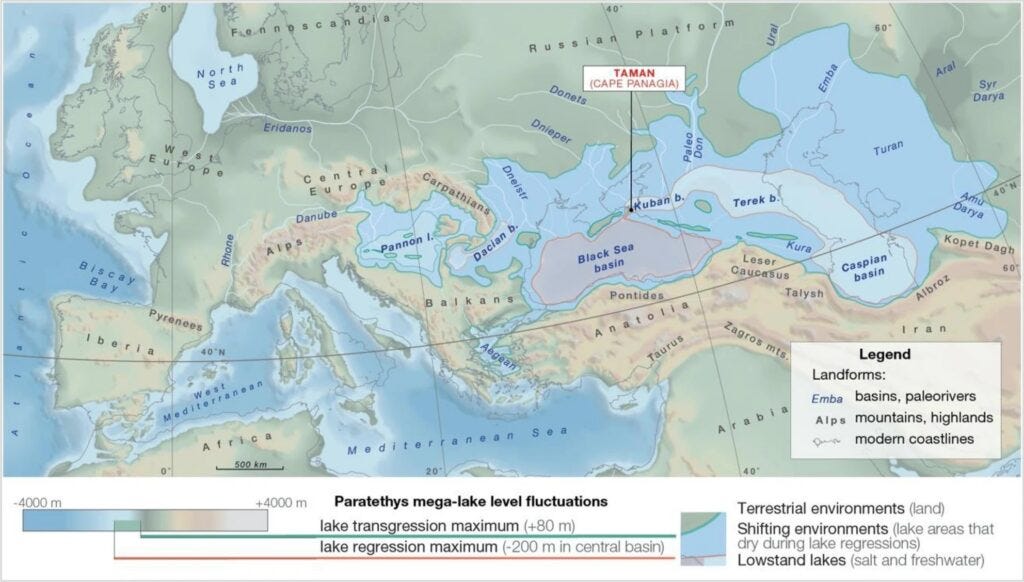
The map above clearly shows how the long mountain range, which links the Alps, the Balkans, the Taurus Mountains, the Zagros Mountains, and the Elburz Mountains forms the southern border of a large body of water. This is the Lake Paratethys, that once stretched from Central Europe to Central Asia. At its maximum extent, it covered 2.8 million square kilometres, an area larger than the current Mediterranean Sea.
This large salt lake connected the Danube basin, the Black Sea, the Caspian Sea and the Aral Sea. This was the case for approximately 25 million years, when the lake began to dry up and lost 70% of its total surface area. The saltwater lakes that remained in the area are a clear remnant of what once was, the most notable examples being the battered Aral Sea and the Caspian Sea, which is still the largest lake on the planet today.
Agassiz, a child of the last ice age
The last ice age, also known as the Würm glaciation in Europe or the Wisconsin glaciation in North America, began 110,000 years ago and lasted until 12,000 years ago. During this period, global temperatures dropped, and large ice sheets formed at the poles. The Laurentide ice sheet covered more than half of the North American continent, extending over 13 million square kilometres. About 20,000 years ago, global temperatures rose again and, as a result, one of the most important lakes of this period was formed: Lake Agassiz.

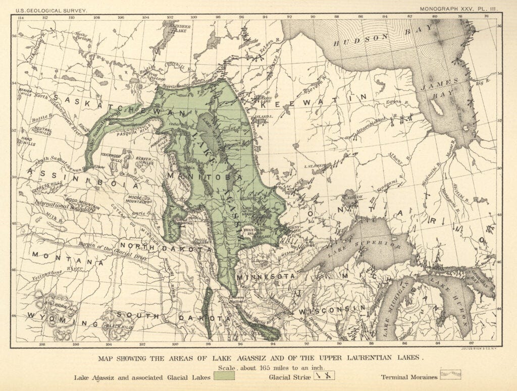
This lake, first theorised in 1832 by William Keating, reached an area of 440,000 square kilometres, slightly larger than the current area of the Caspian Sea. Unlike Lake Paratethys, given its formation as a glacial lake, it was composed of fresh water. And we are talking about a lot of fresh water, more than 163,000 cubic kilometres. So much so that when it drained about 10,000 years ago, it is believed to have contributed to a sea level rise of between 1 and 3 metres.
The drainage was not linear, as global temperature changes led to periods of thawing, followed by short periods during which ice accumulations increased again. This was key to all the consequences of the disappearance of Lake Agassiz, such as climate change in North America, the formation of the Great Lakes. It is even the reason Niagara Falls still exists as the last remnant of what was once that lake4.
The West Siberian Lake, another child of the last ice age
If a large mass of ice covered northern North America, it would be logical to think that the same thing happened in Eurasia, but our intuition would be failing us5. Although large ice sheets did form over Northern Europe and the Arctic Ocean, northern Asia remained mainly a large cold desert. The lack of rainfall and constant winds prevented ice from forming throughout this region. Precisely because of these conditions, when the ice began to melt 20,000 years ago, it was also the perfect place for all that water to accumulate and form multiple glacial lakes, the largest of which was the West Siberian Lake.

This lake occupied part of what we know today as the great plain of West Siberia. Like Lake Agassiz, it was also a freshwater lake, but in this case, it is believed that its maximum size could have been even greater, reaching 750,000 square kilometres, twice the current size of the Caspian Sea6. Melting ice contributed to this, but also the fact that many large Asian rivers were cut off from the sea. That was the case for Ob River, with a basin of 3 million square kilometres, and the Yenisei River, with a basin of 2.5 million square kilometres7.
There are currently several theories about how this lake drained. The most widely accepted is that practically all the water ended up in the Arctic Ocean via the Ob and Yenisei rivers. Others assume that some water overflowed at some point into the Mediterranean Sea, using the ancient Paratethys Sea circuit, as shown in the map above: Turgay River, Aral Sea, Uzboy River, Caspian Sea, Manych River and Black Sea.
Lake Mega-Chad
All of Siberia was a great desert during the last ice age, but that was not true of the great Sahara desert. At the end of this period, around 15,000 years ago, what is known as the African humid period began. Where the Sahara desert is now, there were many lakes, large grasslands and many forest areas. Even the Kilimanjaro glacier field increased significantly in size.
And one lake stood out above all others: Lake Mega-Chad.

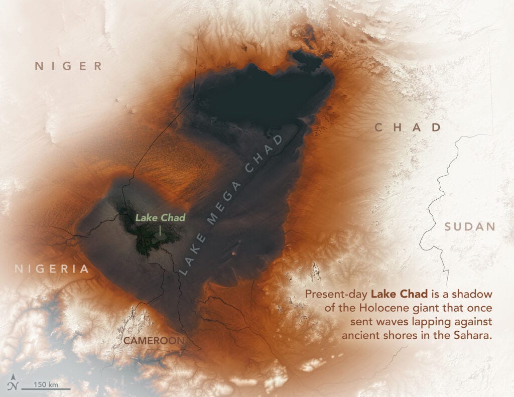
This is the most recent of all the prehistoric lakes I have brought you today, to the point that we can consider it a historical lake. It is believed to have reached its maximum extent around 7,000 years ago and, although estimates vary, it is certain that it was over 400,000 square kilometres, larger than the current Caspian Sea. The most adventurous say that it could have filled the entire endorheic basin where it is located, which would have meant well over 1 million square kilometres, almost three Caspian Seas.

After the end of the glaciation and the extraordinary African humid period, the Sahara gradually regained the upper hand around 6,000 years ago. The many archaeological records from this region show that water remained important for many years, although it is difficult to know exactly how quickly it dried up. What we do know is that in the 19th century, explorers were surprised to find a lake that exceeded 25,000 square kilometres, three times the size of Lake Titicaca today.
With population increases in the surrounding countries of Cameroon, Chad, Niger and Nigeria, pressure on the lake continued to rise. Water loss was unstoppable. Today, only 1,500 square kilometres remain, and the countries in the basin have formed a commission that is investigating how to guarantee the lake's future. The main proposal is to create a canal from the Congo River basin to supply the lake with the necessary water, although there is still a long way to go before the project can be realised.
Edit: Thanks to Sean McKnight for pointing out that the previous image I used for the lakes in North Africa was not accurate. It was taken from a sci-fi map he created a while back, wrongly used by other people.
By popular demand, here’s a button for procrastinating, in case you have plenty of things to do, but you don’t feel like. Each time you click on it, it will take you to a different map from the more than 1,100 in the catalogue.
If you like what you read, don’t hesitate to subscribe to receive an email with each new article that is published.
A relevant article on past and future Pangeaes.
The Theia hypothesis is the most widely accepted theory about the origin of the Moon. According to Greek mythology, Theia was the mother of Selene, goddess of the Moon. A handful of well-chosen names.
Laurasia and Gondwana were the two continents that emerged after the first division of Pangaea, some 175 million years ago.
I dedicated a full article to this a few months ago.
Here is an article on the subject, in case you would like to delve deeper into it.
Today, I'm using the Caspian Sea as my official unit of measurement :).
The Ob River basin is the fourth largest in the world, surpassed only by the Nile, Congo, and Amazon. The Yenisei River basin is the seventh largest in the world, surpassed by the Mississippi and the River Plate.


The Baltic was occasionally a fresh water lake
Very interesting! You, Miguel, are a true Mega-Chad