

The 315 borders of the world
On the idea of borders throughout history, and a compilation of some unique borders in the world.

In the beginning, humanity populated the Earth in the form of nomadic groups that moved from place to place. Different groups interacted occasionally, gathering, separating, or exchanging members. There were occasions when some people settled permanently in a shelter or cave, but it was only a matter of time before they moved on when circumstances forced them to.
We roamed the planet without any strong attachment to the land, at least until we began to settle down about 10,000 years ago1. Humanity established temples, founded cities, and devoted part of the land to agriculture, not necessarily in that order2. Initially, settlements had a limited territory that did not conflict with other nearby groups. But the growth of cities and the increase in social complexity generated the first frictions.
In Mesopotamia, clashes between cities were more or less continuous until the first empires were established. Over the centuries, empires fought each other to determine the area of influence over which they could collect taxes and enlarge their coffers. Those areas of influence of the empires of antiquity were very different from what we understand as borders today. It certainly mattered to whom the inhabitants of a settlement in the middle of the Fertile Crescent paid taxes, but it was irrelevant who had power over a completely uninhabited desert.

With the Roman Empire, the idea of territory and land borders became more complex, partly thanks to the use of the Danube or fortifications such as Hadrian’s Wall. Over the centuries, as settlements increased, borders became more important in determining the territories over which each power ruled. These usually corresponded with some geographical feature, generally rivers and mountain ranges. When Europeans began their colonialist period, this rule for establishing borders was completely overturned, and other, much more arbitrary borders appeared.
As the title of this article states, there are currently 315 borders in the world, depending on how we count them. To arrive at this number, I have relied entirely on this article, which ignores countries with limited recognition and, in addition, counts only a single border between two countries, even though in some cases there are many sections3.
Not all borders are equally relevant, so here are some of the most interesting ones.
The oldest
There is often some disagreement here. It is commonly said that Portugal and Spain have the oldest border in history. It is true that the first modern border was established with the Treaty of Zamora in 1143, but this border underwent many changes in subsequent years. Furthermore, it didn’t take the current shape until the Convention on Limits was signed in 1926, which determines all the details of the current border.
The border that has actually remained unchanged since the 13th century is that of Andorra. In 1278, the Count of Foix and the Archbishop of Urgel signed the Paréage de Andorra, whereby both established joint sovereignty over the current territory of Andorra. It is true that, over the centuries, sovereignty has changed, and Andorra was even invaded by France on several occasions, but this does not detract from the fact that this border has remained in the same shape to this day.

The newest
This one is much more difficult to identify. Borders are constantly changing, either due to specific agreements between countries or because of the many international conflicts that are ongoing. In fact, the vast majority of the world’s borders were defined during the 20th century, with more than 1,200 kilometres drawn so far this century, as shown on this map by Anders Kvernberg.
")
As if that weren’t enough, there are countless territorial conflicts, which make it impossible to define a definitive list of borders agreed upon by all the nations of the world. Some disputes are many years old and are merely symbolic, as in the case of Olivenza, but there are other much more complicated cases, such as China’s claims in Bhutan. Here is another map to give you an idea. In green are the countries that have absolutely no territorial disputes.
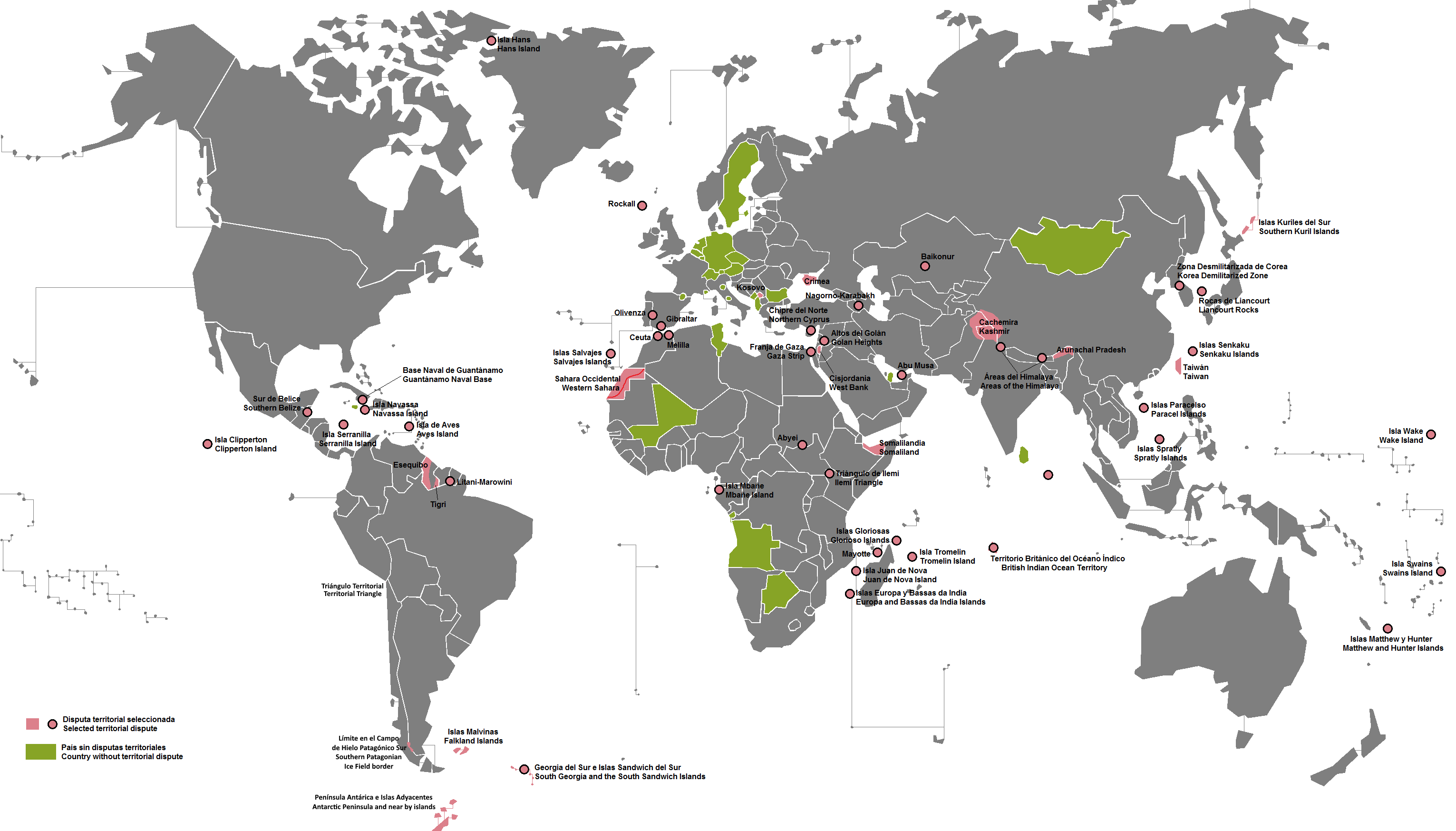
Returning to the most modern border. At the time of publication of this article, September 2025, I am going to take as the most modern border the one that currently exists between Azerbaijan and Armenia. The last time it was modified was in April 2024 with the change of sovereignty over four uninhabited villages. And yes, I am ignoring all current armed conflicts and occupations, since they cannot be considered border changes as such. At least until there is an agreement between the parties.
The longest
This answer may also be more complicated than it might seem. Depending on how a border is defined, measuring it can be as complicated as measuring a coastline.
If it is just a straight line, as is the case for much of the border between the United States and Canada, there should not be any problem. But if the border is defined by a river, then we may again encounter the same difficulty as with the coast of Great Britain4. Ignoring this fact, we have two possible answers to the question of which is the longest border.
If we count all the sections of border shared by two countries, then the longest border would be the one separating Canada and the United States, which is basically divided into two sections: the 48 contiguous states bordering Canada to the north, and Alaska bordering Canada to the east. A total of 8,893 kilometres.

The longest border of the two is only 6,416 kilometres, so if we wanted to count only the longest section, then we would have to go to Russia and Kazakhstan, which share a contiguous border of 7,644 kilometres.
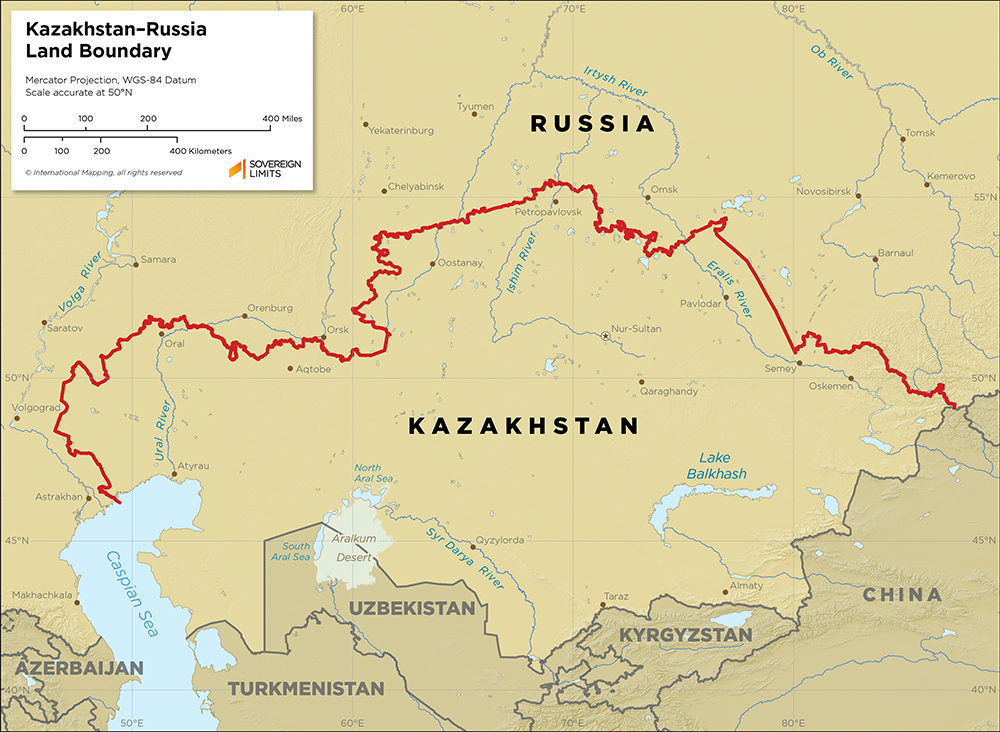
This border, as can be seen, is quite arbitrary. It does not follow the course of the major rivers that cross it, and it has twists and turns that seem difficult to explain at first glance. It was originally defined in the early years of the Soviet Union, in a questionable attempt to create nations within the country that could facilitate stability. After the fall of the USSR, the border automatically became international, although it had to be renegotiated between 1999 and 2006 to take its current form. Which is still quite bizarre.
The shortest
Finally, I want to mention the shortest border in the world, which has an answer as problematic as the case of the longest border in the world.
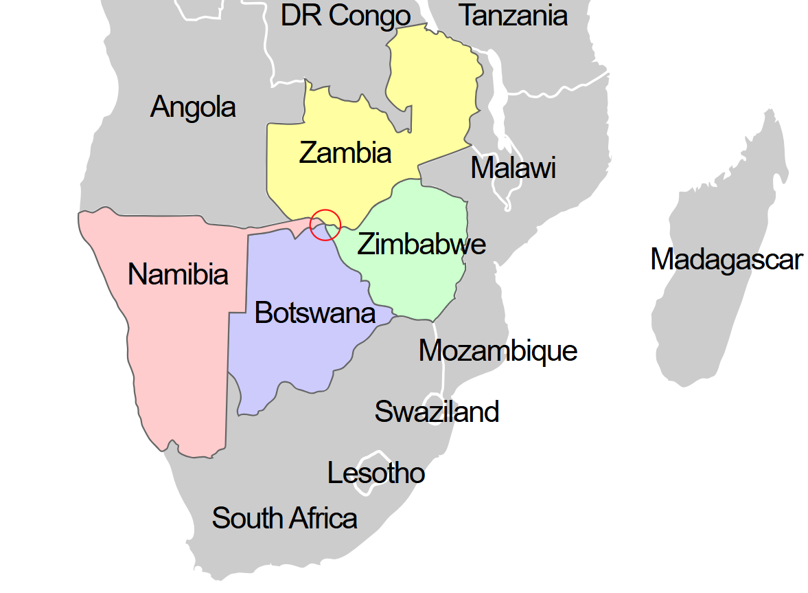
If we stick to the two countries that share a total border with the shortest distance, we find the answer thanks to European colonialism in Africa. The process of decolonization gave rise to the only point where the borders of four countries coincide: Zambia, Zimbabwe, Namibia, and Botswana. And yes, it has a name: it is called an international quadripoint.
With this, the answer could be limited to the fact that there are two pairs of countries that share a border limited to a single point: Botswana-Zambia and Zimbabwe-Namibia. But sadly, this definition is not legal, and this border turns out to be much more mundane. Namibia and Zimbabwe do not share a border, and the border between Zambia and Botswana is 155 meters long. However, it is the shortest border between two countries.

But as with the longest border, we can also talk about the shortest stretch of border dividing two nations. This is a quite well-known fact, but not so much in the rest of the world. It is the short border that separates the Rock of Vélez la Gomera, Spain, from Morocco.

Do you notice the detail of the map above? That’s right, in 1910 Vélez la Gomera was still an island, and would remain so until 1930. An earthquake with its epicentre in Fez pushed the African plate against the Iberian subplate. This produced a slight elevation that would facilitate the raising of some rocks above sea level, against which sand began to pile up and form an isthmus. Today, almost a hundred years later, the accumulated sand has increased the border to 85 meters in length, still the smallest border in the world.
The transition from nomadic to sedentary groups is quite complex. It was a gradual process linked to many other changes in human history, often referred to as the Mesolithic period. Of course, some groups did so on their own, others due to external pressures, and not all at the same time. In fact, nomadic groups still exist today.
In fact, determining the order is part of one of the most difficult questions in history: what led us to create the first cities? There are many articles and books written that evaluate the weight of different social changes that led to the establishment of those first settlements and what things appeared as a consequence.
The most notable case of this is the border between Belgium and the Netherlands, between which there are currently 31 border sections, thanks to the multiple enclaves that exist.
I will write about this in detail in the future, but you can check this meanwhile.
Nitpick: we did *not* roam the planet freely, ever. Hunter-gatherer tribes had very specific borders with their neighbors and killed trespassers on sight. They did roam, but only within their borders.
Such an interesting article, Miguel. To think of ~195 countries with around 315 borders is quite a puzzle, especially with some archipelago nations. Loved the little details, the featured maps and the contentions over the different borders.