

Special #01: Maps of the Roman Empire
A collection of maps covering this fascinating period in history.

Two and a half years ago, several videos of couples talking about the Roman Empire went viral on the internet. More specifically, women asking their boyfriends and husbands how often they thought about the Roman Empire, and many of them were surprised by the answer. Many of the men replied that they thought about the Roman Empire several times a week, and quite a few said they did so every day.
YouGov decided to dedicate an article to this topic, accompanied by a survey. The evidence suggests that the viral moment was guilty of cherry-picking, although the data does support the idea that men think about the Roman Empire more than women.

What it does make more or less clear is that the Roman Empire is a topic of general interest, at least for 60% of those surveyed. So, taking advantage of the fact that I have many maps covering the Roman Empire and its history, I’ve decided to dedicate this first monograph to the subject.
There are 24 maps, and I promise it will be worth it.
1. The Roman Empire (117 AD)
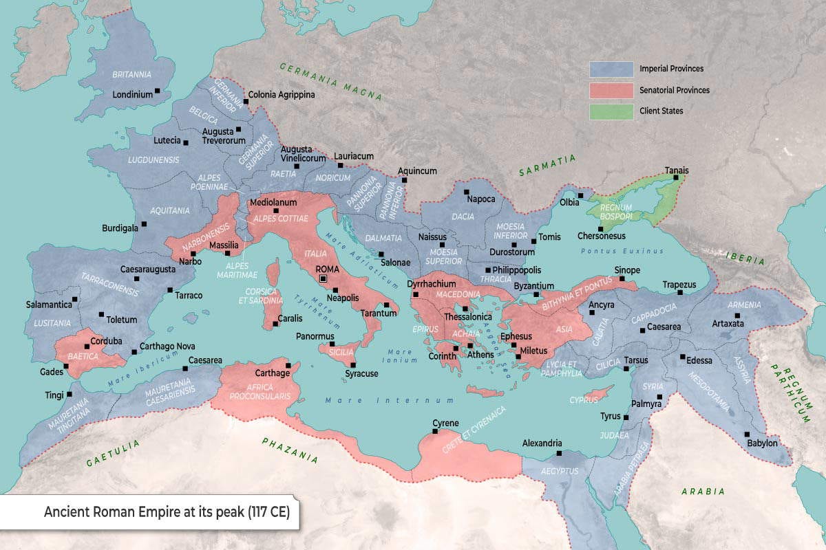
To begin with, here is one of the maps that best illustrates the extent of the empire that people generally have in mind when talking about the Roman Empire. This is usually considered the point at which it reached its greatest extent, at the end of Trajan’s rule, in 117 AD.
You’ll see these borders on many maps, though some will also include territories that were indeed part of Rome at some point, but not necessarily during this period. This is often the case with Caledonia, the southern part of Scotland, between Hadrian’s Wall and the Antonine Wall, which was not conquered until the mid-2nd century. It is also true of some parts of Germania, which were part of Rome during the 1st century but had been completely lost by Trajan’s time.
On this map, and on any other map of the Roman Empire, it is important to understand that the borders drawn as lines were far more diffuse than a map can represent. The borders between countries as we know them today cannot be equated with the borders between powers in Antiquity. In some cases, such as in the Sahara region, borders did not even exist.
2. The Roman conquest of Italy
")
The founding of Rome is usually dated to 753 BC. During the early centuries, it was one of many cities in Italy competing for dominance. Until 509 BC, the city’s system of government was a monarchy, although from that point onwards the Roman Republic was established. By then, Rome had already established itself in its immediate surroundings, and this marked the beginning of its period of expansion across the peninsula.
Initially, expansion was very slow. The first step was to gain control over all the Latin peoples, which was consolidated at the end of the Second Latin War in 338 BC. From that point on, expansion proceeded much more rapidly. Rome had to fight three wars against the Samnites to take control of the entire central region, around 290 BC. It then faced the Etruscans to the north, the Greeks to the south and, finally, the Carthaginians. By the end of the 3rd century BC, the Roman Republic already controlled almost all of Italy and the three major islands: Corsica, Sardinia and Sicily.
3. The territorial expansion of the Roman Republic
")
Over the next two centuries, expansion reached far beyond Italy. The Roman Republic, with its effective army and naval power, took control of the Mediterranean coast of Hispania, all the territories under Carthaginian rule, the eastern Adriatic coast and the southern Balkans.
It also crossed into Asia Minor and took control of the entire coast of Anatolia, eventually reaching Egypt. Shortly before this happened, Julius Caesar achieved one of the most iconic and memorable conquests: that of Gaul.
4. The territorial expansion of the Roman Empire

In 19 BC, during the reign of Augustus, Rome transitioned from a republic to an empire. Augustus had been in power for eight years when he was granted supreme power, the Imperium Maius.
The war machine, which was so economically vital to the Roman Empire, continued to operate and conquer territories. Perhaps the most significant milestone was securing all the coasts of the Mediterranean Sea, which the Romans very descriptively called Mare Nostrum, our sea. But they did not stop there; they managed to establish themselves in Thrace and Dacia, reached the entire Fertile Crescent, and even managed to establish several protectorates that also surrounded the coasts of the Pontus Euxinus, the Black Sea.
5. The Punic Wars
")
As we have briefly seen, Rome waged many wars to achieve such territorial expansion. The wars fought in Italy were local in nature and lacked the scale of a world power of the time. It was not until they faced the Carthaginians that Rome was forced to view war in a different light.
In the First Punic War (264–241 BC), the Roman Republic succeeded in establishing naval supremacy for the first time, which gave it access to Sicily. The Second Punic War (218–201 BC) marked the first large-scale confrontation between Carthage and Rome, in which the Carthaginians proved their worth by putting the Romans on the back foot. However, in the end Rome prevailed and reduced what had been the most powerful force in the Mediterranean to a small, subjugated state that had no right even to defend itself against external aggression.
The Third Punic War (149–146 BC), which is not shown on this map, was the shortest of the three, as it merely involved the definitive destruction of Carthage, to prevent its economic recovery from posing a problem in the future.
6. The Conquest of Gaul

This conquest is very well documented in Bellum Gallicum, a book written by Julius Caesar himself. Precisely for that reason, it is also a gem of propaganda from the period, as it highlights Roman victories, ignores many of the legions’ defeats and excessively glorifies the figure of Julius Caesar.
This map shows the route taken by the Roman campaigns led by Julius Caesar between 58 BC and 51 BC. During those seven years, he fought dozens of battles against various Celtic tribes, which established him as a prestigious military leader. This gave him sufficient power to stand up to Pompey the Great and the Roman Senate, against whom he won the Roman Civil War. Finally, he was appointed dictator for ten years in 46 BC and dictator for life in 44 BC, shortly before he was assassinated.
7. The Legions of Augustus

Augustus, in addition to establishing the Roman Empire, was also responsible for reforming the Roman army and its professionalisation. The legions had previously been temporary formations created solely for specific campaigns, but following the civil wars it became clear that they needed to be made permanent and form the backbone of the Empire.
The 28 new legions did no longer answer to the Senate or to the general who led them, but directly to Augustus. Furthermore, they were distributed, as shown on the map, along the Empire’s most strategic frontiers, both for defence and to serve as occupying forces.
8. The Great Migrations

The Roman Empire reached an extent unknown to any other civilisation up to that time. The war economy helped to ensure Rome’s prosperity, but it was becoming increasingly difficult to sustain these victories over time. In the 3rd century AD, the first temporary breakaways began, such as that of Gaul in the west and Palmyra in the east.
This growing weakness coincided with what is popularly known as the Barbarian Invasions, although it would be more accurate to call it the period of the Migration Period. The term ‘Barbarian Invasions’ was coined by 19th-century historiography, although we now know that what actually happened was a series of peoples migrating from east to west for various reasons. This ultimately led the peoples bordering the Roman Empire to take advantage of its decline to seek a better life in those lands.
This is the context in which we must interpret this map, which shows the multiple incursions of the Huns, the Visigoths, the Vandals, the Suebi and the Alans.
9. The division of the Roman Empire
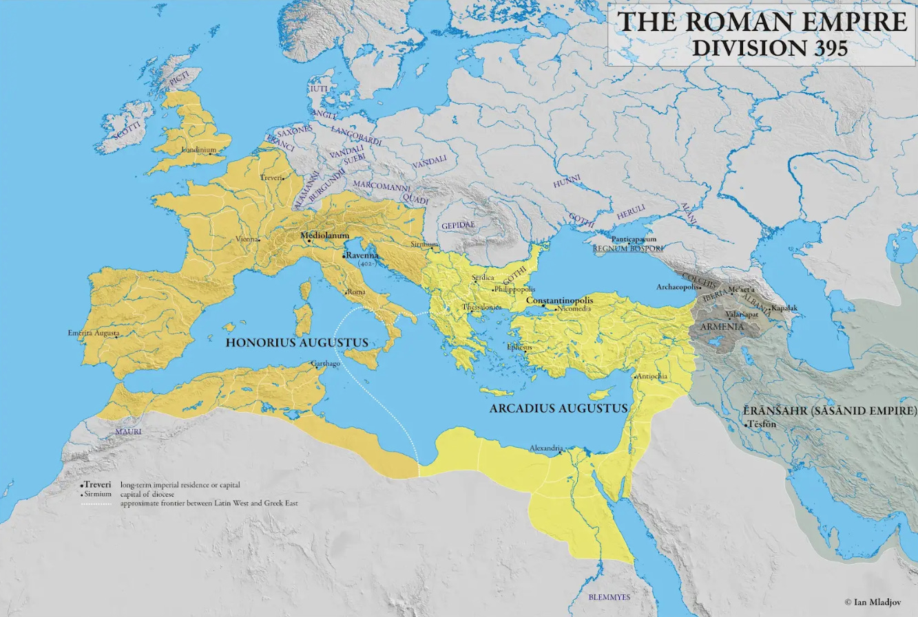
During the Roman Republic, there were two triumvirates that established an informal division of power; the second of these also established a division of the territory among three leaders: Octavian, Mark Antony and Lepidus. That did not end well and, for three centuries, the emperor’s power was absolute over the entire territory.
At the end of the 3rd century AD, Diocletian established the Tetrarchy, through which he divided the empire between two Augusti and two Caesars. The Roman Empire formally remained one, but in reality the four regions operated autonomously, which allowed them to respond to the internal and external threats facing each territory.
Diocletian’s arrangement was not permanent, unlike that of Theodosius in 395 AD, which is shown on this map. Emperor Theodosius granted the Western Roman Empire to his son Honorius and the Eastern Roman Empire to his son Arcadius; as a result, the Roman Empire ceased to exist as a single entity. The West did not last even a hundred years, as the barbarian tribes brought it to an end, but the East remained a regional power for over a thousand years, until the fall of Constantinople in 1453.
10. Forma Urbis Romae
 MET DP828235.jpg")
Not many maps of the Roman Empire have survived. In fact, you can practically count them on the fingers of one hand. We have numerous writings that we know were originally accompanied by maps, such as Ptolemy’s Geographia, but what I wanted to include some original examples that have survived to the present day.
The map above was published in 1756 depicting the existing remains of the Forma Urbis Romae, a gigantic map engraved on marble of the city of Rome. This map dates from the reign of Septimius Severus (203–211 AD) and was originally composed of 150 marble slabs that together measured 18 metres wide and 13 metres high.
Thanks to the little over 10% that has been preserved, we know that the map detailed all the neighbourhoods, streets, and the most important urban buildings. It is not only a unique cartographic gem of the period, but has also been an essential documentary piece for better understanding how the city of Rome was organised and for learning about the structure of some lost buildings.
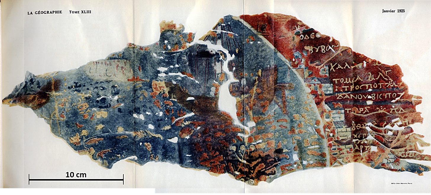
11. Map of the stages of Dura-Europos
It cannot compete with the Forma Urbis Romae in terms of detail and importance, but it is a good example of how common maps were in Ancient Rome.
The map above was found in the city of Dura-Europos, in present-day Syria. It was drawn on the leather that covered a Roman soldier’s shield and is one of the few examples of Roman military cartography. At first glance, it might not seem particularly significant, were it not for the fact that it demonstrates that the Roman army used not only written itineraries but also graphic documents in the form of maps to help them navigate and carry out their missions.

The Dura-Europos route map depicts the various forts and settlements that formed part of a military route along the northern and western coasts of the Black Sea.
12. Anville’s maps


The Roman Empire not only fascinates us today, but is an institution that has attracted people throughout history. This is the reason why it is common to find ancient maps from all the period the Roman Empire existed. This, among other things, helps us to understand in great detail how that period was interpreted at other times in history.
The two maps shown above were drawn by the French cartographer Jean-Baptiste Bourguignon d’Anville in 1764, although they were not published until thirty years later, after his death. The two maps depict the two parts of the Roman Empire, showing its provinces, the main Roman cities and, to make them easier to interpret, the modern names of each of these cities.
These maps help us understand just how much was already known about the Roman Empire over two centuries ago, compared to other civilisations of the time. In case you’re interested, Anville drew several more detailed maps of the Roman Empire, such as this one of Britain and this one of Gaul.
13. Map of Pompeii (1825)
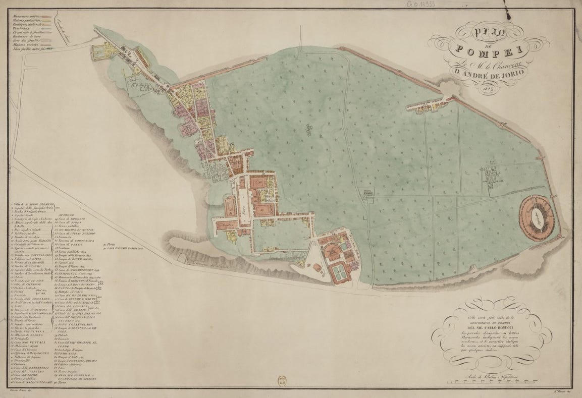
Another example of an ancient map depicting the Roman Empire is this one of the city of Pompeii. It was drawn in 1825 by Andrea de Jorio and is one of the earliest attempts to visually represent the layout of Pompeii. Excavations at Pompeii had only just begun, and very little information was available, though this did not prevent de Jorio from publishing what was known at the time.
In a way, this map of Pompeii aimed to be scientific, although it is clear that its artistic value prevailed. Not because of a lack of intention, but because of the severe lack of information, he had to take many liberties. It is best if you compare it for yourselves with what we currently know about Pompeii.

14. Map of Ancient Rome (1886)

In Pompeii, excavation was necessary to understand what had once stood there, but Rome remained an inhabited city to the present day. That is why no one will be surprised to learn of all the information already available in the 19th century regarding what ancient Rome might have looked like. This map by Gustav Droysen, published in 1886, is a fine example of this.
It shows the trajectory of the two most important walls of ancient Rome: the Servian Walls, dating from the 4th century BC, are shown in dark pink, and the Aurelian Walls, from the 3rd century AD, in light pink. As if that were not enough, the map also includes a vast array of significant monuments and buildings, as well as the 14 regions into which Augustus divided the administration of Rome, numbered from I to XIV.
If you look closely, you can also see on the map the seven hills upon which the city was founded, according to legend: the Aventine (M. Aventinus), the Capitoline (M. Capitolinus), the Caelian (Mons Caelius), the Esquiline (Mons Esquilinus), the Palatine Hill (Mons Palatinus), the Quirinal (Collis Quirinalis) and the Viminal (Collis Viminalis).
15. The growth of Christianity in the Roman Empire

In the decades following the proclamation of the Roman Empire, Christianity emerged in the region of Judea. What began as a small sect within Judaism gradually gained followers throughout the empire over the centuries.
On this map, you can see the cities with a Christian community in the 1st century, marked in blue, and where Christian communities appeared in the 2nd century, marked in purple. At the beginning of the 4th century AD, Constantine declared freedom of worship in the Empire and, with that, Christianity ceased to be persecuted. This is what allowed Christianity to expand from the small concentration of communities, shown in orange, to virtually the entire imperial territory.
Finally, it is also interesting to note on this map the Christian movements that had already been rejected by orthodoxy by the 5th century: Arianism, rejected at the Council of Nicaea (325); Nestorianism, rejected at the Council of Ephesus (431); and Monophysitism, rejected at the Council of Chalcedon (451). All these doctrines, along with any non-Christian religion, were banned after Theodosius established Christianity as the religion of the Empire.
16. The administrative divisions of the Roman Empire

The vastness of the Roman Empire required an efficient administration of the territory. Many other civilisations and empires had already done so before, notably the Achaemenid Empire and its introduction of the satrapies.
The Romans were familiar with territorial structures such as satrapies, which indirectly influenced the creation of their own territorial administration, initially centred on the provinces, as shown on the map. The existing provinces were restructured on multiple occasions, always with the aim of achieving control and efficient administration, which was perhaps not achieved to the same extent as by the Achaemenids, Medes, or Persians.
In the 3rd century, Diocletian and Constantine established new hierarchical levels within the administrative divisions, with the creation of dioceses and praetorian prefectures. The aim at all times was to improve administration, defence capabilities and tax collection.
17. All Roman settlements

So far, we have spoken repeatedly of the vast extent of the Roman Empire, but the uneven distribution of the population across the territory is often overlooked.
I particularly like this map, as it marks all known Roman settlements with a dot. In this way, one can see which regions were, in fact, the most important in the Roman Empire.
There is no doubt that Italy was to play a major role, but perhaps what is surprising is the great significance of the region conquered from Carthage, the whole of Greece, including its islands, and the Anatolian peninsula. The Nile Valley retained the importance it had held in the days of Ancient Egypt, and the entire Mediterranean Levant retained the significance it had held in Phoenician times.
18. The roads of the Roman Empire
")
Another key to the success of Ancient Rome was the creation of a road network connecting every corner of the Empire.
There are hundreds of maps showing this magnificent network, but I have always found this representation, matching a modern underground map, particularly interesting. It was a complex road network, but this simplicity allows us to see clearly how every corner was interconnected, in a decentralised yet highly effective manner for sustaining trade.
If you’re interested, there is an interactive map developed by Stanford University where you can view several additional layers of the road network, as well as the maritime networks and the flow of trade along each of the routes.
19. All the towers and fortifications of the Roman Empire

This other map is very similar to the one we saw above. Just as settlements allow us to see clearly where more people lived, the presence of defensive towers and fortifications helps us understand which were the key areas of the Roman Empire, whether during its period of expansion or its period of decline.
Northern Britain, the entire Rhine basin, Greece, Dacia and western Anatolia are clearly the key areas. This consistently coincides with the regions where the Empire waged its major conflicts against its neighbours over the centuries.
20. Topography of the Roman Empire
")
To conclude, I have two maps that I simply find beautiful.
This one shows the relief of the territory occupied by the Roman Empire at the height of its expansion. To accomplish this, instead of using the classic colours of a physical map, it uses two colours that held special symbolic meaning during the imperial period: purple, linked to imperial power, for the lower-lying areas, and gold, linked to divinity, for the higher ground.
21. A mash-up of Middle-earth and the Roman Empire

As a final map, one that transcends the historical world and ventures into fantasy. It remains a map of Europe with the borders of the Roman Empire, but on this occasion the position of the mountains is altered and blended with elements of the iconography used in the maps of Middle-earth from Tolkien’s books.
I particularly like how the Goths take on the role of Sauron in Mordor, and the other Germanic peoples appear as if they were different tribes of orcs.
By popular demand, here’s a button for procrastinating, in case you have plenty of things to do, but you don’t feel like. Each time you click on it, it will take you to a different map from the more than 1,200 in the catalogue.
If you like what you read, don’t hesitate to subscribe to receive an email with each new article that is published.
So many ideas for future maps, thanks!