Exploring the ocean floor
How humans discovered the ocean floor, surveyed it and managed to represent it on wonderful maps.
The oceans are immense. Up to 70% of the planet's surface is covered by water. Thousands and thousands of kilometres of a world that, until relatively recently, was completely unknown to humanity.
That immensity goes far beyond the surface. It reaches several kilometres deep, with a terrain that is surprisingly changeable and alive. This article is dedicated precisely to the whole story behind the exploration of the ocean floor. And, of course, with the icing on the cake of some iconic maps published by National Geographic about them.
The depth of the ocean
It is tempting to say that ancient peoples had enough to worry about being able to navigate effectively to be concerned with the actual depth of the seas. In reality, the ability to measure the depth of the sea has been essential since ancient times to safely navigate the seas near the coast. At various archaeological sites in the Mediterranean, it has been found lead lines belonging to Greek and Roman sailors, used to determine depth more than 2,000 years ago.
These tools continued to be used during the Middle Ages and the Modern Age. Antonio Pigafetta, chronicler of the Magellan and Elcano expedition, narrates how, in the middle of the Pacific Ocean, upon reaching an atoll, the ship dropped the lead line in multiple places to measure the depth without ever reaching the bottom. At that moment, Magellan was astonished that with more than 700 metres of rope, he had not been able to reach the bottom.

The technology for measuring sea depth, with its limitations, had existed since ancient times, but always to cover the needs of the sailors. Beyond that, who cared where the bottom of the ocean was? As long as they could be sure that the area was safe for navigation, the rest was nothing more than a curiosity with no real value. But this began to change after the expedition to the Aegean Sea led by Edward Forbes. Between 1840 and 1841, Forbes collected biological samples at different depths, reaching 400 metres. With the data obtained, he developed the Azoic Hypothesis or Abyssus Theory, which stated that the deeper the depth, the more hostile the environment became, until it became incompatible with life at depths of 550 metres and below.
Many naturalists fully embraced this idea, so much so that the belief spread that the ocean floor, due to the lack of light, water pressure and low temperatures, was nothing more than a vast desert.
The telegraph and the first bathymetric map of the Atlantic
With the progress made by several inventors in the early 19th century, the telegraph gradually became established as an effective communication system for transmitting information without the need for messengers or visual signals. Through cable systems, first cities and later countries found a way to deliver news at a speed previously unknown. Everything worked perfectly, but only within the boundaries of continents. The coast and the oceans became an invincible barrier.
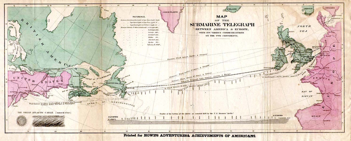
The first submarine cable tests were tested in New York Harbour in 1842, but the materials used were not durable enough to be used on a large scale. A few years later, in 1847, Werner von Siemens1 invented the first durable submarine telegraph cables, thanks to the use of gutta-percha2. This was used to lay the first stable submarine telegraph cable across the English Channel in 1852. And at this point, the question we had been waiting for arose: could a telegraph cable be laid across the bottom of the Atlantic Ocean to connect Europe with the United States?
In 1855, Matthew Fontaine Maury published his most important work, The Physical Geography of the Sea. This work is considered the first detailed and well-founded writing on oceanography. In it, Maury addresses multiple issues, such as the importance of the Gulf Stream, tides, prevailing winds and the saline composition of the waters. But Maury was also fortunate to be studying the Atlantic Ocean at a time when it was necessary to explore the ocean floor. It was required to find the best way to lay a telegraph cable from the United States to the old continent. Thus, between 1853 and 1854, he was able to install measuring systems on several US Navy ships to take measurements at different points in the North Atlantic Ocean.

In The Physical Geography of the Sea, Maury devotes an entire chapter to explaining the measurement systems that were evaluated and ultimately used. After a wonderful reflection on how humans in the mid-19th century had already managed to measure the weight of the planets but were unable to know how deep the ocean was3, Maury devotes another chapter to describing the bathymetry of the North Atlantic Ocean basin. He supplemented this description of the ocean's topography with the first bathymetric map of the Atlantic Ocean, which you can see above.
The knowledge provided by Maury allowed telegraph companies to better understand the complexity of the problem, and in 1858 the first transoceanic submarine telegraph cable was inaugurated, connecting Newfoundland and Ireland. The first message to travel across the two continents was a congratulatory letter from Queen Victoria to James Buchanan, President of the United States, on 16 August of that year.

Within a few days, the transmission speed of that first cable began to decline, as it did the signal quality. To improve service conditions, the decision was made to increase the voltage after three weeks, which caused the cable to break completely. It took seven years to improve the materials and regain the confidence of investors to lay a second cable. In 1866, one year later, a second cable was installed, with mechanisms in place to transmit many more messages.
From that year onwards, the kilometres of submarine cable continued to grow, crossing oceans and seas around the world4. Interestingly, the repair of these cables, located several kilometres below the surface, provided a series of unexpected evidence of the great biodiversity of the ocean floor. This helped to completely dismiss Edward Forbes' Azoic Hypothesis and begin to study this new and peculiar ecosystem.
Mapping the ocean floor
The exploration of the oceans continued on many fronts. One of the most remarkable milestones was the Challenger expedition, which travelled around the world to carry out the first global oceanographic campaign. It set departed in December 1872 from Portsmouth, travelled through the Canary Islands and the Antilles, and ended in Halifax, in present-day Canada. It then continued on to Africa, crossed the ocean again to Brazil, descended into the Antarctic Ocean5, and reached Tasmania, Australia. From there, it travelled across the south-western Pacific Ocean, stopping in Fiji, Indonesia, the Philippines, China, and the Mariana Islands, where depths of over 8,000 metres were recorded in the Mariana Trench.
From there, it began its return journey, passing through Hawaii and Easter Island. It reached the Chilean coast and crossed back into the Atlantic Ocean after rounding Cape Horn, where it made another stop in the Falkland Islands. The last stop was in Spain, finally arriving back in England in May 1876, after three and a half years of expedition. One of the achievements was this first map of the world's ocean floors based on data obtained during the expedition, which also includes the route taken by HMS Challenger in black.

Throughout the 20th century, the methodology, and tools for exploring the ocean floor improved significantly, which brings us to Bruce Heezen and Marie Tharp. These two oceanographers and cartographers met in 1950 while working at the Lamont Geological Observatory, a Columbia University entity dedicated to the study of the origin and evolution of the world in its broadest sense. They soon began collaborating on the tedious task of capturing data and mapping the ocean floor in detail, a task that took them nearly two decades.
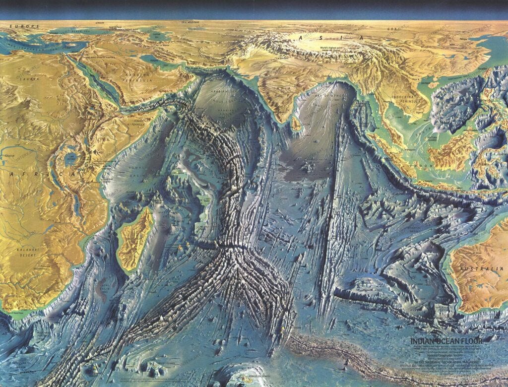
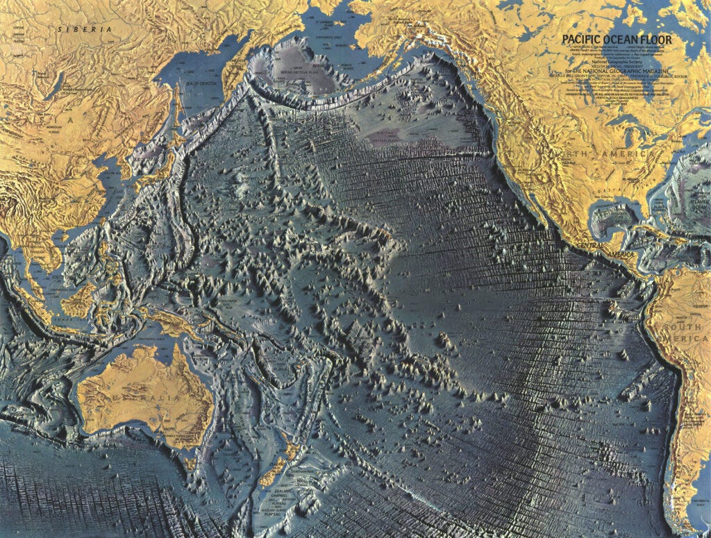
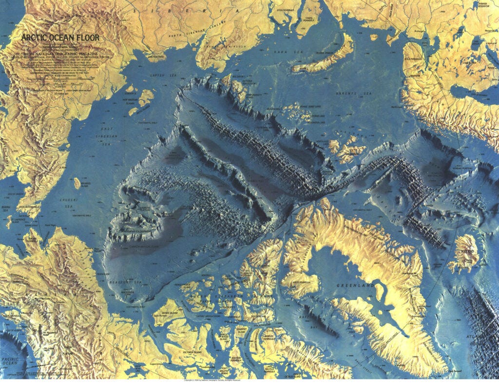
From a scientific perspective, Heezen and Tharp's work can be considered impeccable, but Heinrich Berann was instrumental in popularising their work. In the mid-1960s, Berann was working as an illustrator for National Geographic magazine, which wanted to report on the latest advances in geology, more specifically popularising the theory of plate tectonics. This is how Berann began his collaboration with Heezen and Tharp, which resulted in a series of four magnificent maps published by National Geographic between 1967 and 1971.


It is important to understand the artistic nature of Berann's illustrations, but their informative value is equally undeniable. All these maps show how continental shelves extend beyond the mainland and how ocean basins cover millions of square kilometres. It is easy to see the ocean ridges, where the Earth's crust is formed, but also the trenches and underlying faults where this crust is destroyed.
If we look at archipelagos such as the Canary Islands or Hawaii, it is also possible to understand how many of these islands are hot spots. These are volcanic regions where the crust is perforated by magma, capable of generating new land in the form of islands beyond the ocean ridges.
Yes, this is the same man that founded Siemens. He established the company in 1847.
Gutta-percha is a rubber-like material that is transparent, water-resistant, strong, and flexible.
I could write many paragraphs to detailing all this, but that would be going off on a tangent and would make today's article much longer, so I'll leave you here with the specific chapter in which Maury discusses it.
If you're interested, here is a world map of the entire submarine cable system in 2023. Plus, it's a pretty map.
I also talked about Antarctic exploration recently in the newsletter, you can read it here.


Thanks so much for the write-up, and lovely maps. I'm re-reading Rachel Carson's The Sea Around Us (1951) — this is the perfect, updated yet short version of what we now know of the ocean floor.
There's a nice monument in Halifax to the transatlantic cable. It was hard to capture in photographs but I tried here https://mapoftheweek.substack.com/p/some-maps-in-the-wild-nova-scotia