

Christopher Columbus and the problem of longitude
The story of one of the greatest problems in navigation and cartography for centuries, and how it was solved.

There are many stories to tell about Christopher Columbus. He was a very peculiar character, and a figure who has been used for different purposes over the last 500 years, as
recounted a few days ago in Colombus: Man of History1. Today, I am going to give a brief history of his four voyages, focusing on his disastrous attempts to measure longitude during some of his voyages.And yes, Columbus was a questionable figure in many respects, but the problem with longitude was not due to his ineptitude, but rather to a major measurement problem that all sailors suffered from for centuries.
The voyages of Christopher Columbus
Christopher Columbus was a fortunate man. Despite having had multiple issues with the law in his native Genoa and later in Portugal, he eventually landed in Spain, where he made some good contacts. This allowed him to gain access to the Catholic Monarchs2 and present them with a very crazy way of travelling to the East Indies: across the ocean. Thanks to a series of letters that have been preserved, we know that Columbus believed this was possible thanks to a map by Toscanelli from 1474.
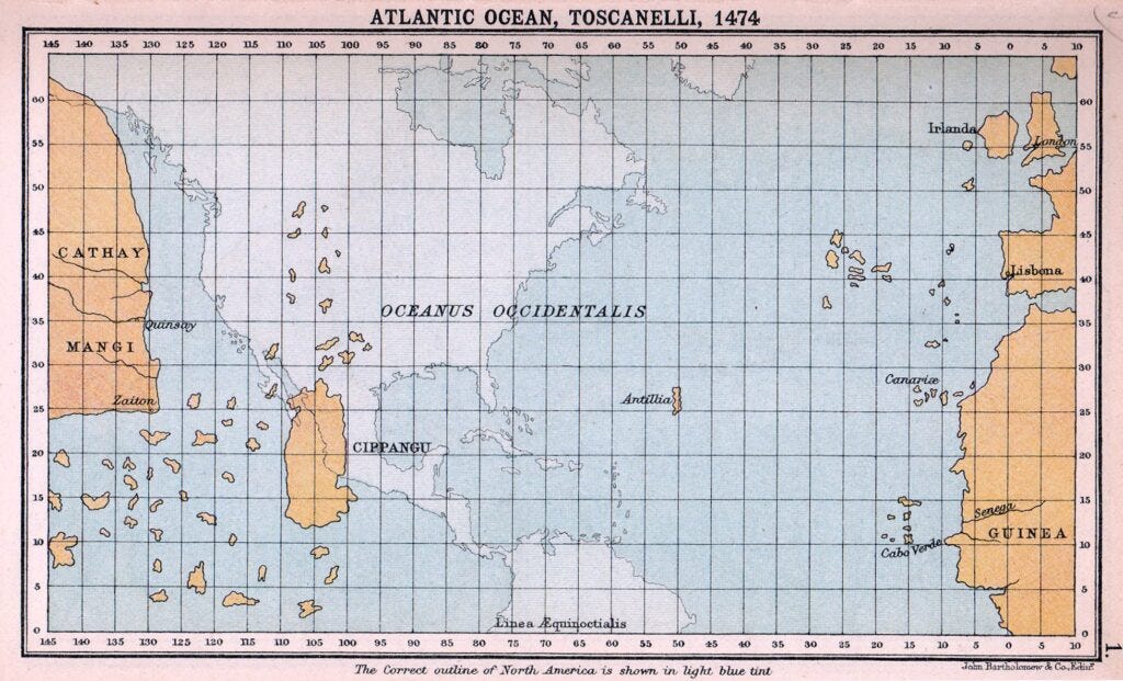
According to Columbus’s plan, the Earth had a circumference at the equator of 29,000 kilometres3, compared to the 40,000 kilometres that Eratosthenes had already proposed in the 3rd century BC and which was still the consensus in Europe. Thanks to this measurement, he calculated that he could easily reach Japan by crossing the ocean, with a strategic stop at the hypothetical island of Antillia halfway across.
The court of the Kingdom of Spain was not at all convinced that this was really possible but, through Ferdinand II of Aragon, he obtained funding in December 1491 to establish an expedition to prove (or disprove) Christopher Columbus’ hypothesis. Thus, he set sail from the port of Palos de la Frontera, in Huelva, on 3 August 1492, with three ships and 86 crew members. A few weeks later, he arrived in the Canary Islands and from there he headed west, searching for the Indies.
")
On 12 October 1492, the expedition finally reached its destination, which Columbus believed to be the East Indies, but was, in fact, the Bahamas archipelago. From there they sailed to Cuba and finally to the island of Hispaniola. After the sinking of the Santa María, Columbus decided to begin his return journey to bring the news to the Catholic Monarchs. The discovery of this new route was warmly welcomed, as it was much faster than the usual route, circumnavigating Africa, and gave Spain a competitive advantage in improving its trade network. Thanks to this, Columbus obtained funding for a second voyage, which set sail at the end of 1493 with 17 ships and more than 1,500 crew members.
But where had Columbus actually arrived?
Christopher Columbus’ measurements
On his second voyage, Columbus was determined to find out where he had actually arrived. Taking advantage of a lunar eclipse, he attempted to measure his position when he was east of Hispaniola, near what is now Punta Cana, in present-day Dominican Republic. There he determined that he was 80° west of Cape St. Vincent, southwest of Portugal. The measurement was quite disastrous, as this point is actually where the Yucatán Peninsula is located, in present-day Mexico, 2,200 kilometres away.

After the second voyage, Columbus’ situation became complicated. He also began to have problems with the Spanish justice system. He still managed to make two more voyages, but with a much smaller crew and less relevance to the plans of the Spanish Empire. During his fourth voyage, Columbus again took advantage of a lunar eclipse to try to determine his position once more. On this occasion, he was in the northern coast of Jamaica, and he estimated that he was 100° west of Cape St. Vincent. The measurement on his first voyage had been poor, but the one on the fourth voyage turned out to be much worse. 100° west of Cape St. Vincent is a point in the middle of the Pacific Ocean, south of the California peninsula, 3,800 kilometres away.

If you notice, in both measurements, Columbus was able to estimate his latitude (north-south axis) quite accurately, but he failed miserably in his longitude (east-west axis). Why is this? Measuring latitude is easy, something that the Phoenicians and Polynesians were already capable of doing several centuries before Christ, but measuring longitude was practically impossible without an accurate clock that worked perfectly. In other words, not by calculating the solar time at each point, but a universal time4.
The consensus is that Amerigo Vespucci hypothesised that the lands reached by the Spanish Empire were, in fact, a new continent. Columbus died in 1507, quite possibly without ever really realising that he had reached a continent unknown to Europeans.
The problem of longitude
The mathematical problem of longitude and latitude has been solved since the days of Ancient Greece. In the 3rd century BC, Eratosthenes proposed that the Earth was spherical with a diameter of 40,000 kilometres and proposed a map dividing the world using meridians and parallels. Meridians were defined as lines connecting the North Pole and the South Pole, which were used to measure the longitude of any point on the Earth’s surface. Parallels, on the other hand, were defined as lines perpendicular to the meridians, which were used to measure the latitude of any point.

In the 2nd century BC, Hipparchus of Nicaea provided the information needed to measure latitude and longitude. For latitude, the difficulty was solved with a series of tools to measure the height of the sun at noon, at its highest point, and a series of tables that defined latitude based on the time of year5.
Longitude, on the other hand, is measured relatively. Hipparchus already knew that the sun rises earlier in cities further east and later in cities further west. If we take a day to be 24 hours long and the 360° into which the terrestrial sphere is divided, each hour corresponds to 15° of longitude difference. All that was needed was to measure time, and this is where technology fell short and prevented the application of Hipparchus’ perfectly defined theory.

.jpg)
For centuries, many scientists and inventors attempted to solve the problem of longitude. All the European powers threw themselves into this problem and offered multiple prizes in an attempt to find someone who could give them a competitive advantage in navigating the seas more effectively. Finally, in the mid-18th century, John Harrison, an English clockmaker, succeeded in finding the mechanism. With the aim of winning the prize offered by the English Parliament in 1714, he devoted much of his life to creating an accurate clock that would make him worthy of the £10,000 promised as the prize.
His first model, the H-1, was presented in 1737. Thanks to it, he gained the attention of Parliament, although he did not win the prize. This allowed him access to more funding, enabling him to design more models, until in 1760 he presented the H-4, the clock that would change everything. It was first tested on a voyage from England to Jamaica and, over the course of 81 days, the clock was only 5 seconds slow, which was a notable success. Even so, the scepticism of Parliament and many scientists of the time caused John Harrison to never receive the full prize. Thanks to pressure from George III, he did manage to get part of it paid out.
Although the problem of longitude had been solved in practical terms by John Harrison, the problem persisted in navigation, as access to such clocks was expensive and few ships could afford them. This is why the popularisation of the telegraph throughout the 19th century was so important. This new technology allowed instantaneous point-to-point communication across the globe, making it easier to compare the time between two points and thus effectively determine longitude without the need for a clock to be moved from one point to another.

This map, published in France at the beginning of the 20th century, shows the telegraph network that existed at that time. At the same time, it also accurately depicts the coasts of the entire land surface, without the measurement aberrations that had been so common in previous centuries. The invention of radio at the beginning of that same century also solved the problem of longitude for all sailors, as it allowed them to communicate instantly with control towers that helped determine the position of the ship.
And with that, the problem of longitude was finally solved.
And he will be writing in the coming weeks about Columbus, in case you are interested in the topic.
How Queen Isabella I of Castile and King Ferdinand II of Aragon are commonly known.
Or 32,000 kilometres, depending on the source consulted.
Speaking of time, I dedicated three articles to how we learned to measure time, you can start with this one.
Due to the translational movement, the height of the sun at midday changes throughout the year.
well, thanks. The original problem of longitude escapes me. The clock solution suggests it was a question of messuring the time since departure. Why was the hourglass not used? The time to run them is known, one can turn over many of them when it ran out of sand. Just 1 person each day to look after them. However, even with the time travelled known, it seems to me that the original problem is not well established, because the distance travelled depends on the speed of the boot. But this is not mentioned at all. This all puzzles me.
I approached this from another angle:
https://open.substack.com/pub/thomasfdavis/p/the-flat-earth?r=bbwgp&utm_medium=ios